
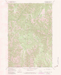
~ Godman Spring WA topo map, 1:24000 scale, 7.5 X 7.5 Minute, Historical, 1967, updated 1983
Godman Spring, Washington, USGS topographic map dated 1967.
Includes geographic coordinates (latitude and longitude). This topographic map is suitable for hiking, camping, and exploring, or framing it as a wall map.
Printed on-demand using high resolution imagery, on heavy weight and acid free paper, or alternatively on a variety of synthetic materials.
Topos available on paper, Waterproof, Poly, or Tyvek. Usually shipping rolled, unless combined with other folded maps in one order.
- Product Number: USGS-5404496
- Free digital map download (high-resolution, GeoPDF): Godman Spring, Washington (file size: 15 MB)
- Map Size: please refer to the dimensions of the GeoPDF map above
- Weight (paper map): ca. 55 grams
- Map Type: POD USGS Topographic Map
- Map Series: HTMC
- Map Verison: Historical
- Cell ID: 17563
- Scan ID: 241338
- Imprint Year: 1983
- Woodland Tint: Yes
- Visual Version Number: 1
- Photo Revision Year: 1983
- Aerial Photo Year: 1981
- Edit Year: 1983
- Field Check Year: 1967
- Datum: NAD27
- Map Projection: Polyconic
- Map published by United States Geological Survey
- Map Language: English
- Scanner Resolution: 600 dpi
- Map Cell Name: Godman Spring
- Grid size: 7.5 X 7.5 Minute
- Date on map: 1967
- Map Scale: 1:24000
- Geographical region: Washington, United States
Neighboring Maps:
All neighboring USGS topo maps are available for sale online at a variety of scales.
Spatial coverage:
Topo map Godman Spring, Washington, covers the geographical area associated the following places:
- Burnt Flat Corral - Wildcat Spring - Fuzzy Butte - Little Turkey Tail - Grizzly Bear Trail - Buck Ridge - Preacher Creek - Twin Buttes Spring - Berry Spring - Happy Valley - Sugarloaf - Lady Camp - Bluewood Ski Area - Rainbow Creek Research Natural Area - Beaver Ridge - Middle Point Ridge - Coyote Spring - Deer Spring - Godman Campground - Slick Ear Trail - West Butte Creek Trail - Lady Spring - Little Turkey Recreation Residence - Dexter Spring - Elwell Spring - Beaver Ridge - Rainbow Creek - Godman Guard Station - Zuger Spring - Deep Saddle Creek - Touchet Sno-Park - Dexter Ridge - Sawtooth Ridge - Dexter Ridge Trail - Sawtooth Trail - Mead Spring - Stayawhile Spring - Burnt Flat - Manilla Spring - Twin Buttes - Godman Spring - Cavalier Spring - Chase Mountain
- Map Area ID: AREA46.12546-117.875-117.75
- Northwest corner Lat/Long code: USGSNW46.125-117.875
- Northeast corner Lat/Long code: USGSNE46.125-117.75
- Southwest corner Lat/Long code: USGSSW46-117.875
- Southeast corner Lat/Long code: USGSSE46-117.75
- Northern map edge Latitude: 46.125
- Southern map edge Latitude: 46
- Western map edge Longitude: -117.875
- Eastern map edge Longitude: -117.75


