
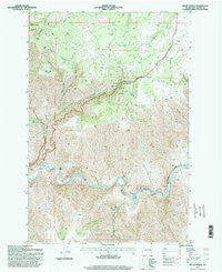
~ Fields Spring WA topo map, 1:24000 scale, 7.5 X 7.5 Minute, Historical, 1995, updated 1998
Fields Spring, Washington, USGS topographic map dated 1995.
Includes geographic coordinates (latitude and longitude). This topographic map is suitable for hiking, camping, and exploring, or framing it as a wall map.
Printed on-demand using high resolution imagery, on heavy weight and acid free paper, or alternatively on a variety of synthetic materials.
Topos available on paper, Waterproof, Poly, or Tyvek. Usually shipping rolled, unless combined with other folded maps in one order.
- Product Number: USGS-5404220
- Free digital map download (high-resolution, GeoPDF): Fields Spring, Washington (file size: 17 MB)
- Map Size: please refer to the dimensions of the GeoPDF map above
- Weight (paper map): ca. 55 grams
- Map Type: POD USGS Topographic Map
- Map Series: HTMC
- Map Verison: Historical
- Cell ID: 15233
- Scan ID: 241138
- Imprint Year: 1998
- Woodland Tint: Yes
- Aerial Photo Year: 1994
- Field Check Year: 1995
- Datum: NAD27
- Map Projection: Lambert Conformal Conic
- Map published by United States Geological Survey
- Map published by United States Forest Service
- Map Language: English
- Scanner Resolution: 600 dpi
- Map Cell Name: Fields Spring
- Grid size: 7.5 X 7.5 Minute
- Date on map: 1995
- Map Scale: 1:24000
- Geographical region: Washington, United States
Neighboring Maps:
All neighboring USGS topo maps are available for sale online at a variety of scales.
Spatial coverage:
Topo map Fields Spring, Washington, covers the geographical area associated the following places:
- Ray School - Big Butte - Deep Canyon - West Branch Rattlesnake Creek - Benson Ridge - Fields Spring - Alder Gulch - Box Canyon - Morengo Spring - Kunh Landing Strip (historical) - Deer Flat - Fields Spring State Park - Tamarack Spring - Deer Creek - Puffer Butte
- Map Area ID: AREA46.12546-117.25-117.125
- Northwest corner Lat/Long code: USGSNW46.125-117.25
- Northeast corner Lat/Long code: USGSNE46.125-117.125
- Southwest corner Lat/Long code: USGSSW46-117.25
- Southeast corner Lat/Long code: USGSSE46-117.125
- Northern map edge Latitude: 46.125
- Southern map edge Latitude: 46
- Western map edge Longitude: -117.25
- Eastern map edge Longitude: -117.125


