
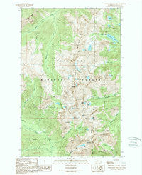
~ Chiwaukum Mountains WA topo map, 1:24000 scale, 7.5 X 7.5 Minute, Historical, 1989, updated 1989
Chiwaukum Mountains, Washington, USGS topographic map dated 1989.
Includes geographic coordinates (latitude and longitude). This topographic map is suitable for hiking, camping, and exploring, or framing it as a wall map.
Printed on-demand using high resolution imagery, on heavy weight and acid free paper, or alternatively on a variety of synthetic materials.
Topos available on paper, Waterproof, Poly, or Tyvek. Usually shipping rolled, unless combined with other folded maps in one order.
- Product Number: USGS-5403354
- Free digital map download (high-resolution, GeoPDF): Chiwaukum Mountains, Washington (file size: 18 MB)
- Map Size: please refer to the dimensions of the GeoPDF map above
- Weight (paper map): ca. 55 grams
- Map Type: POD USGS Topographic Map
- Map Series: HTMC
- Map Verison: Historical
- Cell ID: 8629
- Scan ID: 240501
- Imprint Year: 1989
- Woodland Tint: Yes
- Visual Version Number: 2
- Aerial Photo Year: 1963
- Edit Year: 1989
- Field Check Year: 1987
- Datum: NAD27
- Map Projection: Lambert Conformal Conic
- Provisional map: Yes
- Map published by United States Geological Survey
- Map Language: English
- Scanner Resolution: 600 dpi
- Map Cell Name: Chiwaukum Mountains
- Grid size: 7.5 X 7.5 Minute
- Date on map: 1989
- Map Scale: 1:24000
- Geographical region: Washington, United States
Neighboring Maps:
All neighboring USGS topo maps are available for sale online at a variety of scales.
Spatial coverage:
Topo map Chiwaukum Mountains, Washington, covers the geographical area associated the following places:
- Ewing Basin - Spanish Camp Creek - Lake Flore - Knox Lake - Lake Margaret - Chiwaukum Mountains - Frosty Creek - Frosty Pass - French Creek Campground - Grindstone Mountain - French Creek - Brule Creek - Lake Julius - Honour Lake - Lake Edna - Lake Grace - Cup Lake - Lake Charles - Ladies Pass - Deadhorse Pass - Lake Alice - Lake Jason - Chiwaukum Lake - Cape Horn - Packrat Camp - Lower Florence Lake - Loch Eileen - Lake Sylvester - Snowgrass Mountain - Upper Grace Lake - Lake Brigham - Wildhorse Creek - Larch Lake - Jason Lakes - Lake Mary - Upper Florence Lake - Lake Donald
- Map Area ID: AREA47.7547.625-121-120.875
- Northwest corner Lat/Long code: USGSNW47.75-121
- Northeast corner Lat/Long code: USGSNE47.75-120.875
- Southwest corner Lat/Long code: USGSSW47.625-121
- Southeast corner Lat/Long code: USGSSE47.625-120.875
- Northern map edge Latitude: 47.75
- Southern map edge Latitude: 47.625
- Western map edge Longitude: -121
- Eastern map edge Longitude: -120.875


