
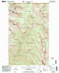
~ Castle Peak WA topo map, 1:24000 scale, 7.5 X 7.5 Minute, Historical, 2002, updated 2006
Castle Peak, Washington, USGS topographic map dated 2002.
Includes geographic coordinates (latitude and longitude). This topographic map is suitable for hiking, camping, and exploring, or framing it as a wall map.
Printed on-demand using high resolution imagery, on heavy weight and acid free paper, or alternatively on a variety of synthetic materials.
Topos available on paper, Waterproof, Poly, or Tyvek. Usually shipping rolled, unless combined with other folded maps in one order.
- Product Number: USGS-5403218
- Free digital map download (high-resolution, GeoPDF): Castle Peak, Washington (file size: 20 MB)
- Map Size: please refer to the dimensions of the GeoPDF map above
- Weight (paper map): ca. 55 grams
- Map Type: POD USGS Topographic Map
- Map Series: HTMC
- Map Verison: Historical
- Cell ID: 7584
- Scan ID: 240384
- Imprint Year: 2006
- Woodland Tint: Yes
- Aerial Photo Year: 2002
- Datum: NAD83
- Map Projection: Universal Transverse Mercator
- Map published by United States Geological Survey
- Map published by United States Forest Service
- Map Language: English
- Scanner Resolution: 600 dpi
- Map Cell Name: Castle Peak
- Grid size: 7.5 X 7.5 Minute
- Date on map: 2002
- Map Scale: 1:24000
- Geographical region: Washington, United States
Neighboring Maps:
All neighboring USGS topo maps are available for sale online at a variety of scales.
Spatial coverage:
Topo map Castle Peak, Washington, covers the geographical area associated the following places:
- Powder Mountain - Woody Pass - King Creek - Two Buttes Creek - Lakeview Ridge - North Cascade Primitive Area (historical) - Rustle Creek - Castle Pass - Trouble Creek - Coney Basin - Big Face Creek - Pacific Crest National Scenic Trail - Shull Creek - Mountain Home Camp - Hopkins Lake - Princess Creek - Blizzard Peak - Frosty Pass - Mount Winthrop - Rock Creek - Hopkins Pass - Three Fools Peak - Castle Peak - Castle Fork - Route Creek - Devils Stairway - Queen Creek - Crow Creek
- Map Area ID: AREA4948.875-120.875-120.75
- Northwest corner Lat/Long code: USGSNW49-120.875
- Northeast corner Lat/Long code: USGSNE49-120.75
- Southwest corner Lat/Long code: USGSSW48.875-120.875
- Southeast corner Lat/Long code: USGSSE48.875-120.75
- Northern map edge Latitude: 49
- Southern map edge Latitude: 48.875
- Western map edge Longitude: -120.875
- Eastern map edge Longitude: -120.75


