
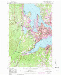
~ Bremerton West WA topo map, 1:24000 scale, 7.5 X 7.5 Minute, Historical, 1953, updated 1982
Bremerton West, Washington, USGS topographic map dated 1953.
Includes geographic coordinates (latitude and longitude). This topographic map is suitable for hiking, camping, and exploring, or framing it as a wall map.
Printed on-demand using high resolution imagery, on heavy weight and acid free paper, or alternatively on a variety of synthetic materials.
Topos available on paper, Waterproof, Poly, or Tyvek. Usually shipping rolled, unless combined with other folded maps in one order.
- Product Number: USGS-5402958
- Free digital map download (high-resolution, GeoPDF): Bremerton West, Washington (file size: 16 MB)
- Map Size: please refer to the dimensions of the GeoPDF map above
- Weight (paper map): ca. 55 grams
- Map Type: POD USGS Topographic Map
- Map Series: HTMC
- Map Verison: Historical
- Cell ID: 5351
- Scan ID: 240213
- Imprint Year: 1982
- Woodland Tint: Yes
- Photo Revision Year: 1981
- Aerial Photo Year: 1978
- Edit Year: 1981
- Field Check Year: 1953
- Datum: NAD27
- Map Projection: Polyconic
- Map published by United States Geological Survey
- Map Language: English
- Scanner Resolution: 600 dpi
- Map Cell Name: Bremerton West
- Grid size: 7.5 X 7.5 Minute
- Date on map: 1953
- Map Scale: 1:24000
- Geographical region: Washington, United States
Neighboring Maps:
All neighboring USGS topo maps are available for sale online at a variety of scales.
Spatial coverage:
Topo map Bremerton West, Washington, covers the geographical area associated the following places:
- Charleston - Country Lane - Fernwood - Northlake Mobile Home Park - Chico - Fairview - Sunnyslope - Camelot Mobile Estates - Naval Depot Junction - Jackson Park - Bremerton - Rocky Point - Rocky Point Mobile Home Park - Bremerton Junction - Erlands Point Mobile Home Park - Heritage Mobile Home Park - Kitsap Lake Mobile Home Park - Berry Lake Manor Mobile Home Park - Sherman Heights - Madrona Point - Carrington Mobile Home Park - Navy Yard City - Eastwood - Erlands Point - West Park - Sheridan Park - Orchard Bluff Mobile Home Park - Aero Mobile Court - Silverdale Mobile Estates - McCurry Heights Mobile Home Park - Port Orchard - Marine Drive - East Bremerton - Eldorado Hills - Gorst - Kitsap Lake - Tracyton - Sheridan
- Map Area ID: AREA47.62547.5-122.75-122.625
- Northwest corner Lat/Long code: USGSNW47.625-122.75
- Northeast corner Lat/Long code: USGSNE47.625-122.625
- Southwest corner Lat/Long code: USGSSW47.5-122.75
- Southeast corner Lat/Long code: USGSSE47.5-122.625
- Northern map edge Latitude: 47.625
- Southern map edge Latitude: 47.5
- Western map edge Longitude: -122.75
- Eastern map edge Longitude: -122.625


