
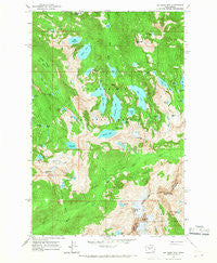
~ Big Snow Mtn WA topo map, 1:24000 scale, 7.5 X 7.5 Minute, Historical, 1965, updated 1967
Big Snow Mtn, Washington, USGS topographic map dated 1965.
Includes geographic coordinates (latitude and longitude). This topographic map is suitable for hiking, camping, and exploring, or framing it as a wall map.
Printed on-demand using high resolution imagery, on heavy weight and acid free paper, or alternatively on a variety of synthetic materials.
Topos available on paper, Waterproof, Poly, or Tyvek. Usually shipping rolled, unless combined with other folded maps in one order.
- Product Number: USGS-5402746
- Free digital map download (high-resolution, GeoPDF): Big Snow Mtn, Washington (file size: 17 MB)
- Map Size: please refer to the dimensions of the GeoPDF map above
- Weight (paper map): ca. 55 grams
- Map Type: POD USGS Topographic Map
- Map Series: HTMC
- Map Verison: Historical
- Cell ID: 3835
- Scan ID: 240059
- Imprint Year: 1967
- Woodland Tint: Yes
- Aerial Photo Year: 1958
- Field Check Year: 1965
- Datum: NAD27
- Map Projection: Polyconic
- Map published by United States Geological Survey
- Map Language: English
- Scanner Resolution: 600 dpi
- Map Cell Name: Big Snow Mountain
- Grid size: 7.5 X 7.5 Minute
- Date on map: 1965
- Map Scale: 1:24000
- Geographical region: Washington, United States
Neighboring Maps:
All neighboring USGS topo maps are available for sale online at a variety of scales.
Spatial coverage:
Topo map Big Snow Mtn, Washington, covers the geographical area associated the following places:
- Bald Eagle Peak - Bonnie Lake - Moira Lake - Lake Malachite - Hardscrabble Lakes - Charlie Lakes - Iron Cap Mountain - Bald Eagle Lake - Big Heart Lake - Hardscrabble Creek - Jewel Lake - Big Snow Lake - Overcoat Peak - Opal Lake - Copper Lake - Summit Chief Mountain - Chimney Rock - Emerald Lake - Tank Lakes - Locket Lake - Malachite Peak - Necklace Valley - Azure Lake - Silver Eagle Peak - Crawford Creek - Cecils Lake - Summit Chief Lake - Foehn Lake - Angeline Lake - Little Heart Lake - Hinter Lake - Trout Lake - Cloudy Lake - Gus Lake - Fools Gold Lake - Azurite Lake - Nazanne Lake - Chetwoot Lake - Big Snow Mountain - Gold Lake - Lake Ilswoot - View Lake - Necklace Valley Lakes - Overcoat Lake - Delta Lake - Marlene Lake - Malachite Falls - Little Chetwoot Lake - Snowflake Lake - Tahl Lake - Crawford Lake - Iceberg Lake - Otter Lake - Camp Robber Lake - Jade Lake
- Map Area ID: AREA47.62547.5-121.375-121.25
- Northwest corner Lat/Long code: USGSNW47.625-121.375
- Northeast corner Lat/Long code: USGSNE47.625-121.25
- Southwest corner Lat/Long code: USGSSW47.5-121.375
- Southeast corner Lat/Long code: USGSSE47.5-121.25
- Northern map edge Latitude: 47.625
- Southern map edge Latitude: 47.5
- Western map edge Longitude: -121.375
- Eastern map edge Longitude: -121.25


