
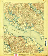
~ Nomini VA topo map, 1:125000 scale, 30 X 30 Minute, Historical, 1898, updated 1923
Nomini, Virginia, USGS topographic map dated 1898.
Includes geographic coordinates (latitude and longitude). This topographic map is suitable for hiking, camping, and exploring, or framing it as a wall map.
Printed on-demand using high resolution imagery, on heavy weight and acid free paper, or alternatively on a variety of synthetic materials.
Topos available on paper, Waterproof, Poly, or Tyvek. Usually shipping rolled, unless combined with other folded maps in one order.
- Product Number: USGS-5368674
- Free digital map download (high-resolution, GeoPDF): Nomini, Virginia (file size: 11 MB)
- Map Size: please refer to the dimensions of the GeoPDF map above
- Weight (paper map): ca. 55 grams
- Map Type: POD USGS Topographic Map
- Map Series: HTMC
- Map Verison: Historical
- Cell ID: 65240
- Scan ID: 257732
- Imprint Year: 1923
- Survey Year: 1890
- Datum: Unstated
- Map Projection: Unstated
- Map published by United States Geological Survey
- Map Language: English
- Scanner Resolution: 600 dpi
- Map Cell Name: Colonial
- Grid size: 30 X 30 Minute
- Date on map: 1898
- Map Scale: 1:125000
- Geographical region: Virginia, United States
Neighboring Maps:
All neighboring USGS topo maps are available for sale online at a variety of scales.
Spatial coverage:
Topo map Nomini, Virginia, covers the geographical area associated the following places:
- Potomac Mills - Island Creek - Oaks - Hillville - Horners - Holly Oaks - East End - Shady Dale - Wildwood - Society Hill - Pinemore - Colonial Beach - Templeman - Ross Woods - Newport - Stratford Hall - Shiloh - Birch Hanger - Burnt Mill - Indiantown - Fenwick Manor - Ryceville - Scotch Point - Chaptico - Sexton Hill - Middle Earth - Goodwins - Baynesville - Gravelly Hills - Chickasaw Run - Tallent Town - Maddox - Kenwood Beach - Layton - Golden Beach - Saint Catherine - Flat Iron - Halls Hacienda - Battle (historical) - Cobb Island - Lower Brambley (historical) - Home Place - Sandy Point - Queen Tree Landing - Harts (historical) - Briscoe - Leming - Valley Lee - Hard Corner - Cal Acres - Ramey Fork - Pawpaw Hollow - Farmers Fork - Olde Mill - Kinsale - Classic Shore - Birkwood Estates - Winterseat - Clover Dale Acres - Bel Alton - Sandgates - Herring Creek Estates - Chingville - Husick Estates - Ridgewood - Currioman Landing - Meter - Nomini Grove - Budds Creek - Compton - Knollcrest - Newmarket - Long Cove Estates - Lukes Island (historical) - Hellen - Callaway - Mechanicsville - Riverwood Farms - Williams Wharf - Cooney Neck Estate - Bull Neck - Dubois Park - Sandyland Beach - Lane Beach - Harbor Hills - Saint Marys Beach - Tall Timbers - Champlain - Charleston Creek - Trenton Place - Oraville - Thompson Corner - Mutual Consent - Myrtle Point - Thomas Manor - Country Lakes - Mutual Estates - Collingwood - Acorn - Mill Cove Manor
- Map Area ID: AREA38.538-77-76.5
- Northwest corner Lat/Long code: USGSNW38.5-77
- Northeast corner Lat/Long code: USGSNE38.5-76.5
- Southwest corner Lat/Long code: USGSSW38-77
- Southeast corner Lat/Long code: USGSSE38-76.5
- Northern map edge Latitude: 38.5
- Southern map edge Latitude: 38
- Western map edge Longitude: -77
- Eastern map edge Longitude: -76.5


