
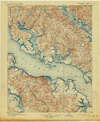
~ Nomini VA topo map, 1:125000 scale, 30 X 30 Minute, Historical, 1898, updated 1914
Nomini, Virginia, USGS topographic map dated 1898.
Includes geographic coordinates (latitude and longitude). This topographic map is suitable for hiking, camping, and exploring, or framing it as a wall map.
Printed on-demand using high resolution imagery, on heavy weight and acid free paper, or alternatively on a variety of synthetic materials.
Topos available on paper, Waterproof, Poly, or Tyvek. Usually shipping rolled, unless combined with other folded maps in one order.
- Product Number: USGS-5368670
- Free digital map download (high-resolution, GeoPDF): Nomini, Virginia (file size: 10 MB)
- Map Size: please refer to the dimensions of the GeoPDF map above
- Weight (paper map): ca. 55 grams
- Map Type: POD USGS Topographic Map
- Map Series: HTMC
- Map Verison: Historical
- Cell ID: 65240
- Scan ID: 189100
- Imprint Year: 1914
- Survey Year: 1890
- Datum: Unstated
- Map Projection: Unstated
- Map published by United States Geological Survey
- Map Language: English
- Scanner Resolution: 600 dpi
- Map Cell Name: Colonial
- Grid size: 30 X 30 Minute
- Date on map: 1898
- Map Scale: 1:125000
- Geographical region: Virginia, United States
Neighboring Maps:
All neighboring USGS topo maps are available for sale online at a variety of scales.
Spatial coverage:
Topo map Nomini, Virginia, covers the geographical area associated the following places:
- Bryant Town - Williams Wharf - Harbor Hills - Parker Wharf - Forrest Hall Estates - Chippingwood - West Hatton - Hillville - Hurry - Chiltons - Flat Iron - Beauvue - Rogers Mill - Redgate - Rolling Hills - Burning Oaks - Red Hill - Land-O-Lakes - Denby Hill - Abell - Collingwood - Mechanicsville - Emerald Cove - Montross - Goodwins - Tolson - Stratford Mill - Hellen - Country Lakes - Summerseat Village - Maple Run - Callaway - Sotterley - Laurel Grove - Britton - Widow Woods - Allens Fresh - Deer Park - Rolling Acres - Middle Earth - Peeds - Hard Corner - Another Place - Dubois Park - Piney Grove - Green Acres - Blakistone - Hollywood Shores - Holly Haven - Waterloo - Morrisons Corner - Loveville - Leonardtown - Oraville - Burnt Mill - Ridgewood - Trenton Place - East End - Patterson Park - Coltons Point - Mutual Estates - Springfield - Chisford - Piney Point Shores - Holly Gaf Acres - Drumcliff - Battle (historical) - Cellar Hill - Cremona - Mount Holly - Chingville - Husick Estates - Potomac Beach - Hollywood - Barefoot Acres - Breton Beach - Halls Hacienda - Huckleberry - Zacata - Knollcrest - Peacock Manor - Lukes Island (historical) - Old Sycamore Estates - Horners - Wallville - Templeman - Maryland Manor - Society Hill - The Plains - Oaks - Tintop Hill - Havelock - Potomac Shores - Amys Acres - Gilbert Acres - Hillside Manor - Wakefield (historical) - Dubois - Singerly - Longview Beach
- Map Area ID: AREA38.538-77-76.5
- Northwest corner Lat/Long code: USGSNW38.5-77
- Northeast corner Lat/Long code: USGSNE38.5-76.5
- Southwest corner Lat/Long code: USGSSW38-77
- Southeast corner Lat/Long code: USGSSE38-76.5
- Northern map edge Latitude: 38.5
- Southern map edge Latitude: 38
- Western map edge Longitude: -77
- Eastern map edge Longitude: -76.5


