
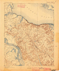
~ Montross VA topo map, 1:62500 scale, 15 X 15 Minute, Historical, 1895, updated 1901
Montross, Virginia, USGS topographic map dated 1895.
Includes geographic coordinates (latitude and longitude). This topographic map is suitable for hiking, camping, and exploring, or framing it as a wall map.
Printed on-demand using high resolution imagery, on heavy weight and acid free paper, or alternatively on a variety of synthetic materials.
Topos available on paper, Waterproof, Poly, or Tyvek. Usually shipping rolled, unless combined with other folded maps in one order.
- Product Number: USGS-5368314
- Free digital map download (high-resolution, GeoPDF): Montross, Virginia (file size: 8 MB)
- Map Size: please refer to the dimensions of the GeoPDF map above
- Weight (paper map): ca. 55 grams
- Map Type: POD USGS Topographic Map
- Map Series: HTMC
- Map Verison: Historical
- Cell ID: 64177
- Scan ID: 257517
- Imprint Year: 1901
- Survey Year: 1890
- Datum: Unstated
- Map Projection: Unstated
- Map published by United States Geological Survey
- Map Language: English
- Scanner Resolution: 600 dpi
- Map Cell Name: Wakefield
- Grid size: 15 X 15 Minute
- Date on map: 1895
- Map Scale: 1:62500
- Geographical region: Virginia, United States
Neighboring Maps:
All neighboring USGS topo maps are available for sale online at a variety of scales.
Spatial coverage:
Topo map Montross, Virginia, covers the geographical area associated the following places:
- Chisford - Potomac Mills - Laurel Grove - Wakefield (historical) - East End - Havelock - Piney Grove - Oak Grove - Singerly - River Springs - Horners - Sexton Hill - Newland - Germans Corner - Lukes Island (historical) - Bryant Town - Lerty - Foneswood - Waterloo - Zacata - Currioman Landing - Coltons Point - Peeds - Ramey Fork - Palmers - Champlain - Chiltons - Wakefield Corner - Flat Iron - Stratford Mill - Montross - Springfield - Baynesville - Layton - Farmers Fork - China Hill - Latanes - Leedstown - Oak Row - Monroe Hall - Templeman - Tallent Town - Stratford Hall - Harts (historical)
- Map Area ID: AREA38.2538-77-76.75
- Northwest corner Lat/Long code: USGSNW38.25-77
- Northeast corner Lat/Long code: USGSNE38.25-76.75
- Southwest corner Lat/Long code: USGSSW38-77
- Southeast corner Lat/Long code: USGSSE38-76.75
- Northern map edge Latitude: 38.25
- Southern map edge Latitude: 38
- Western map edge Longitude: -77
- Eastern map edge Longitude: -76.75


