
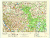
~ Eau Claire WI topo map, 1:250000 scale, 1 X 2 Degree, Historical, 1953, updated 1975
Eau Claire, Wisconsin, USGS topographic map dated 1953.
Includes geographic coordinates (latitude and longitude). This topographic map is suitable for hiking, camping, and exploring, or framing it as a wall map.
Printed on-demand using high resolution imagery, on heavy weight and acid free paper, or alternatively on a variety of synthetic materials.
Topos available on paper, Waterproof, Poly, or Tyvek. Usually shipping rolled, unless combined with other folded maps in one order.
- Product Number: USGS-5309876
- Free digital map download (high-resolution, GeoPDF): Eau Claire, Wisconsin (file size: 12 MB)
- Map Size: please refer to the dimensions of the GeoPDF map above
- Weight (paper map): ca. 55 grams
- Map Type: POD USGS Topographic Map
- Map Series: HTMC
- Map Verison: Historical
- Cell ID: 68763
- Scan ID: 801531
- Imprint Year: 1975
- Woodland Tint: Yes
- Aerial Photo Year: 1953
- Edit Year: 1964
- Field Check Year: 1953
- Datum: Unstated
- Map Projection: Transverse Mercator
- Map published by United States Geological Survey
- Map Language: English
- Scanner Resolution: 508 dpi
- Map Cell Name: Eau Claire
- Grid size: 1 X 2 Degree
- Date on map: 1953
- Map Scale: 1:250000
- Geographical region: Wisconsin, United States
Neighboring Maps:
All neighboring USGS topo maps are available for sale online at a variety of scales.
Spatial coverage:
Topo map Eau Claire, Wisconsin, covers the geographical area associated the following places:
- York - Colfax - Elk Creek - Arpin - Trow (historical) - Trempealeau - Colby - Glencoe - Pine Creek - Fountain City - Irvine - Stockton - Cloverdale - Auburndale - Mondovi - Owen - Hatfield - Milan - Merrillan - Greenwood - Brackett - Gilmanton - Alma - Millston - Longwood - Hillcrest Estates Mobile Home Park - Veedum - Menominee - Sprague - Berghs Mobile Home Park - Pine Edge Mobile Home Park - Price - Fall Hall Glen - Northfield - Nelsonville (historical) - City Point - Bakerville - North Tomah - Cortland (historical) - Urne - Sheppard - North Branch - Country Valley Mobile Home Park - Pigeon Falls - Norway Ridge - Putnam Heights - Dewey Corners - Hidden Valley Mobile Home Village - Elk Mound - Eidsvold - Goodview - Finley - Meadow Valley - Altura - Centerville - Camino Mobile Home Park - Anchorage (historical) - Veefkind - Blair - Thorp - Swan - Rock Falls - Lynn - Cataract - Mindoro - Chapultepee - Hixton - Christie - Maples Mobile Home Park - Anson - Green Acres - Weber - Humbird - Rusk - Shawtown - Black River Falls - Willard - Riplinger - Bluff Siding - Homer - Durand - Wuertsburg - Sidney - Czechville - Bright - Hegg - Shamrock - Hewitt - Unity - Rodell - Pinehurst - West Prairie - Oak Ridge Village Mobile Home Park - Bluff Crest Mobile Home Park - Menomonie Junction - Whitman - Cutler - Tarrant - Taylor - Upper French Creek
- Map Area ID: AREA4544-92-90
- Northwest corner Lat/Long code: USGSNW45-92
- Northeast corner Lat/Long code: USGSNE45-90
- Southwest corner Lat/Long code: USGSSW44-92
- Southeast corner Lat/Long code: USGSSE44-90
- Northern map edge Latitude: 45
- Southern map edge Latitude: 44
- Western map edge Longitude: -92
- Eastern map edge Longitude: -90


