
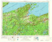
~ Ashland WI topo map, 1:250000 scale, 1 X 2 Degree, Historical, 1953, updated 1975
Ashland, Wisconsin, USGS topographic map dated 1953.
Includes geographic coordinates (latitude and longitude). This topographic map is suitable for hiking, camping, and exploring, or framing it as a wall map.
Printed on-demand using high resolution imagery, on heavy weight and acid free paper, or alternatively on a variety of synthetic materials.
Topos available on paper, Waterproof, Poly, or Tyvek. Usually shipping rolled, unless combined with other folded maps in one order.
- Product Number: USGS-5309866
- Free digital map download (high-resolution, GeoPDF): Ashland, Wisconsin (file size: 14 MB)
- Map Size: please refer to the dimensions of the GeoPDF map above
- Weight (paper map): ca. 55 grams
- Map Type: POD USGS Topographic Map
- Map Series: HTMC
- Map Verison: Historical
- Cell ID: 72216
- Scan ID: 801368
- Imprint Year: 1975
- Woodland Tint: Yes
- Edit Year: 1963
- Field Check Year: 1953
- Datum: Unstated
- Map Projection: Transverse Mercator
- Map published by United States Geological Survey
- Map Language: English
- Scanner Resolution: 508 dpi
- Map Cell Name: Ashland
- Grid size: 1 X 2 Degree
- Date on map: 1953
- Map Scale: 1:250000
- Geographical region: Wisconsin, United States
Neighboring Maps:
All neighboring USGS topo maps are available for sale online at a variety of scales.
Spatial coverage:
Topo map Ashland, Wisconsin, covers the geographical area associated the following places:
- South Range - Knife River - Iron Belt - Waino - Hoyt - Dobie - Bennett - White City - Clam Lake - Benoit - Harmon (historical) - Marengo - Bessemer - Phipps - Port Wing - Barksdale - Sauntry - Rockmont - Radspur - Hines - Clifton - Delta - Old Fort - Sutherland - Lake Nebagamon - Herbster - Auvinen Corner - Drummond - Salmo - Topside - Sioux - Moquah - Springstead - North Bessemer - Montreal - Larsmont - Cable - Cedar - Minersville - Red Cliff - Bark Point - Ironwood - Hillcrest - Iron River - Bellwood - Gordon - Gile - Leonards - Manitowish - Foster Junction - White River - Poplar - Namekagon - Lake Owen - Glidden - Hawthorne - Tyler Forks - Morse - Parkland - Germania - Lake Owen (historical) - La Pointe - Cayuga - Minong - Maple - Cornucopia - Pence - Bayfield - Yale - Seeley - Butternut - Shanagolden - Ballou - Chittamo - Saxon - Kimball - Orva - Rouse - Hautala Corner - Jessieville - Middle River - Sedgwick - Beebe - Cutter - Hurley - Pureair - North Ironwood - Lakewood - Wills - Mercer - Ashland - Pike River - Cloverland - Muskeg - Petes Landing - Middleport - Aurora - Junet - Siemens - Ashland Junction
- Map Area ID: AREA4746-92-90
- Northwest corner Lat/Long code: USGSNW47-92
- Northeast corner Lat/Long code: USGSNE47-90
- Southwest corner Lat/Long code: USGSSW46-92
- Southeast corner Lat/Long code: USGSSE46-90
- Northern map edge Latitude: 47
- Southern map edge Latitude: 46
- Western map edge Longitude: -92
- Eastern map edge Longitude: -90


