
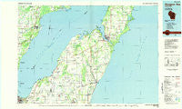
~ Sturgeon Bay WI topo map, 1:100000 scale, 30 X 60 Minute, Historical, 1984, updated 1985
Sturgeon Bay, Wisconsin, USGS topographic map dated 1984.
Includes geographic coordinates (latitude and longitude). This topographic map is suitable for hiking, camping, and exploring, or framing it as a wall map.
Printed on-demand using high resolution imagery, on heavy weight and acid free paper, or alternatively on a variety of synthetic materials.
Topos available on paper, Waterproof, Poly, or Tyvek. Usually shipping rolled, unless combined with other folded maps in one order.
- Product Number: USGS-5309812
- Free digital map download (high-resolution, GeoPDF): Sturgeon Bay, Wisconsin (file size: 19 MB)
- Map Size: please refer to the dimensions of the GeoPDF map above
- Weight (paper map): ca. 55 grams
- Map Type: POD USGS Topographic Map
- Map Series: HTMC
- Map Verison: Historical
- Cell ID: 68420
- Scan ID: 803117
- Imprint Year: 1985
- Woodland Tint: Yes
- Aerial Photo Year: 1980
- Edit Year: 1984
- Datum: NAD27
- Map Projection: Universal Transverse Mercator
- Planimetric: Yes
- Map published by United States Geological Survey
- Map Language: English
- Scanner Resolution: 508 dpi
- Map Cell Name: Sturgeon Bay
- Grid size: 30 X 60 Minute
- Date on map: 1984
- Map Scale: 1:100000
- Geographical region: Wisconsin, United States
Neighboring Maps:
All neighboring USGS topo maps are available for sale online at a variety of scales.
Spatial coverage:
Topo map Sturgeon Bay, Wisconsin, covers the geographical area associated the following places:
- Luxemburg - Clyde - Bay View - Alaska - Dyckesville - Lincoln - Chapel Ridge - Oak Orchard - Edgewater Beach - Kolberg - Vignes - Wilcox - County Line - New Franken - Highland Heights Mobile Village - Rostok - Ryans Corner - Tonet - Sturgeon Bay - Whitefish Bay - Forestville - Carlsville - Shoemaker Point - North Baird Mobile Home Park - Oconto - Wequiock - Rankin - Pensaukee - Valmy - Casco Junction - Humboldt - Gregorville - Champion - Brookside - Institute - Kodan - Euren - Sugar Bush - Idlewild - Rio Creek - Maplewood - Algoma - Bruemmerville - Stevens Hill - Brussels - Willems Mobile Home Park - A and V Terrace Gardens - Casco - Carnot - Duvall - Bay Settlement - Neuern - Namur - Walhain - Salona - Little Sturgeon - Haevers Corners - Cullen - Benderville - Slovan - Jacksonport - Red Banks - Thiry Daems - Rosiere
- Map Area ID: AREA4544.5-88-87
- Northwest corner Lat/Long code: USGSNW45-88
- Northeast corner Lat/Long code: USGSNE45-87
- Southwest corner Lat/Long code: USGSSW44.5-88
- Southeast corner Lat/Long code: USGSSE44.5-87
- Northern map edge Latitude: 45
- Southern map edge Latitude: 44.5
- Western map edge Longitude: -88
- Eastern map edge Longitude: -87


