
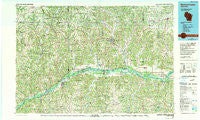
~ Richland Center WI topo map, 1:100000 scale, 30 X 60 Minute, Historical, 1985, updated 1991
Richland Center, Wisconsin, USGS topographic map dated 1985.
Includes geographic coordinates (latitude and longitude). This topographic map is suitable for hiking, camping, and exploring, or framing it as a wall map.
Printed on-demand using high resolution imagery, on heavy weight and acid free paper, or alternatively on a variety of synthetic materials.
Topos available on paper, Waterproof, Poly, or Tyvek. Usually shipping rolled, unless combined with other folded maps in one order.
- Product Number: USGS-5309794
- Free digital map download (high-resolution, GeoPDF): Richland Center, Wisconsin (file size: 21 MB)
- Map Size: please refer to the dimensions of the GeoPDF map above
- Weight (paper map): ca. 55 grams
- Map Type: POD USGS Topographic Map
- Map Series: HTMC
- Map Verison: Historical
- Cell ID: 68233
- Scan ID: 803114
- Imprint Year: 1991
- Woodland Tint: Yes
- Photo Inspection Year: 1986
- Aerial Photo Year: 1983
- Edit Year: 1985
- Datum: NAD27
- Map Projection: Universal Transverse Mercator
- Map published by United States Geological Survey
- Map Language: English
- Scanner Resolution: 508 dpi
- Map Cell Name: Richland Center
- Grid size: 30 X 60 Minute
- Date on map: 1985
- Map Scale: 1:100000
- Geographical region: Wisconsin, United States
Neighboring Maps:
All neighboring USGS topo maps are available for sale online at a variety of scales.
Spatial coverage:
Topo map Richland Center, Wisconsin, covers the geographical area associated the following places:
- Blue River - Petersburg - Gillingham - Towerville - Castle Rock - Evergreen Terrace - Oak Ridge Estates - Port Andrew - Mill Creek (historical) - Soldiers Grove - Woodman - Pleasant Ridge - Jimtown - Rux Mobile Home Park - Ashford (historical) - Loreta - Clyde - Harmony Hill - Readstown - Johnstown - Plugtown - Sugar Grove - Sand Prairie - Excelsior - Orion - Loyd - Bear Valley - Wauzeka - Barnum - Gays Mills - Rockbridge - Pine Knob - Hill Point - Mount Zion - Twin Bluffs - Sandusky - Lime Ridge - Avoca - North Clayton - Loganville - Boydtown - Plain - Spring Green - Five Points - Buck Creek - Hub City - Liberty Pole - Gotham - Bell Center - McGrew (historical) - Rolling Ground - Yankeetown - Sabin - Byrds Creek - Bunker Hill - Rising Sun - Richland Center - Mount Sterling - Helena - Sextonville - Millville - Hickory Grove - Ithaca - Highland - Westport - Easter Rock - Centerville - Sylvan - Bloom City - Keyesville - Seneca - Fargo - Balmoral - Wild Rose - Steuben - Bosstown - Montgomeryville - Homer - Woodstock - Werley - Basswood - Folsom - Muscoda - Lone Rock - Tavera - Aubrey - Boscobel - Neptune - Wyoming - Fairview - Boaz
- Map Area ID: AREA43.543-91-90
- Northwest corner Lat/Long code: USGSNW43.5-91
- Northeast corner Lat/Long code: USGSNE43.5-90
- Southwest corner Lat/Long code: USGSSW43-91
- Southeast corner Lat/Long code: USGSSE43-90
- Northern map edge Latitude: 43.5
- Southern map edge Latitude: 43
- Western map edge Longitude: -91
- Eastern map edge Longitude: -90


