
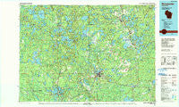
~ Rhinelander WI topo map, 1:100000 scale, 30 X 60 Minute, Historical, 1989, updated 1990
Rhinelander, Wisconsin, USGS topographic map dated 1989.
Includes geographic coordinates (latitude and longitude). This topographic map is suitable for hiking, camping, and exploring, or framing it as a wall map.
Printed on-demand using high resolution imagery, on heavy weight and acid free paper, or alternatively on a variety of synthetic materials.
Topos available on paper, Waterproof, Poly, or Tyvek. Usually shipping rolled, unless combined with other folded maps in one order.
- Product Number: USGS-5309792
- Free digital map download (high-resolution, GeoPDF): Rhinelander, Wisconsin (file size: 19 MB)
- Map Size: please refer to the dimensions of the GeoPDF map above
- Weight (paper map): ca. 55 grams
- Map Type: POD USGS Topographic Map
- Map Series: HTMC
- Map Verison: Historical
- Cell ID: 68229
- Scan ID: 803113
- Imprint Year: 1990
- Woodland Tint: Yes
- Aerial Photo Year: 1986
- Edit Year: 1989
- Datum: NAD27
- Map Projection: Universal Transverse Mercator
- Map published by United States Geological Survey
- Map Language: English
- Scanner Resolution: 508 dpi
- Map Cell Name: Rhinelander
- Grid size: 30 X 60 Minute
- Date on map: 1989
- Map Scale: 1:100000
- Geographical region: Wisconsin, United States
Neighboring Maps:
All neighboring USGS topo maps are available for sale online at a variety of scales.
Spatial coverage:
Topo map Rhinelander, Wisconsin, covers the geographical area associated the following places:
- McNaughton - Sayner - Starks - Roosevelt - Malvern - Lake Tomahawk - Hazelhurst - Three Lakes - Sugar Camp - Goodnow - Atkins - Crescent Corner - Monico - Tripoli - Bradley - Harshaw - McCord - Saint Germain - Lennox - Nashville - Jeffris - Minocqua - Rantz - Woodboro - Sunflower - Gagen - Heafford Junction - Clearwater Lake - Rhinelander - Lac du Flambeau - Newbold - Eagle River - Jennings - Marlands - Woodruff - Arbor Vitae - Manson (historical)
- Map Area ID: AREA4645.5-90-89
- Northwest corner Lat/Long code: USGSNW46-90
- Northeast corner Lat/Long code: USGSNE46-89
- Southwest corner Lat/Long code: USGSSW45.5-90
- Southeast corner Lat/Long code: USGSSE45.5-89
- Northern map edge Latitude: 46
- Southern map edge Latitude: 45.5
- Western map edge Longitude: -90
- Eastern map edge Longitude: -89


