
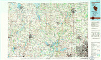
~ Oconomowoc WI topo map, 1:100000 scale, 30 X 60 Minute, Historical, 1991, updated 1991
Oconomowoc, Wisconsin, USGS topographic map dated 1991.
Includes geographic coordinates (latitude and longitude). This topographic map is suitable for hiking, camping, and exploring, or framing it as a wall map.
Printed on-demand using high resolution imagery, on heavy weight and acid free paper, or alternatively on a variety of synthetic materials.
Topos available on paper, Waterproof, Poly, or Tyvek. Usually shipping rolled, unless combined with other folded maps in one order.
- Product Number: USGS-5309782
- Free digital map download (high-resolution, GeoPDF): Oconomowoc, Wisconsin (file size: 17 MB)
- Map Size: please refer to the dimensions of the GeoPDF map above
- Weight (paper map): ca. 55 grams
- Map Type: POD USGS Topographic Map
- Map Series: HTMC
- Map Verison: Historical
- Cell ID: 68079
- Scan ID: 803112
- Imprint Year: 1991
- Woodland Tint: Yes
- Aerial Photo Year: 1986
- Edit Year: 1991
- Datum: NAD27
- Map Projection: Universal Transverse Mercator
- Map published by United States Geological Survey
- Map Language: English
- Scanner Resolution: 508 dpi
- Map Cell Name: Oconomowoc
- Grid size: 30 X 60 Minute
- Date on map: 1991
- Map Scale: 1:100000
- Geographical region: Wisconsin, United States
Neighboring Maps:
All neighboring USGS topo maps are available for sale online at a variety of scales.
Spatial coverage:
Topo map Oconomowoc, Wisconsin, covers the geographical area associated the following places:
- Pike Lake - Hubbleton - Aztalan - Elm Grove - Horicon - Cedar Creek - Summit Corners - Clyman - West Granville - Sullivan - Lost Lake - Lowell - Kohler - Huilsburg - Ebenezer - Village Terrace Mobile Home Park - Monterey - Hochheim - Plat - Thompson - Goldenthal - Delafield - Johnson Creek - Old Ashippun - Cedar Lake - Jackson - Rockfield - Portland - Milford - West Bend - Clyman Junction - Ackerville - Iron Ridge - Lake Mills - Saint Lawrence - Barton - Addison - Lannon - Allenton - Oak Grove - Jefferson - Beaver Dam - Grellton - Duplainville - Rolling Prairie - Meeker - North Lake - Waterville - Lake Five - Oconomowoc Lake - Waukesha - Granville - Decker Corner - Young America - Freistadt - Beaver Edge - Colgate - Hartford - Horns Corners - North Lowell - Oconomowoc - Okauchee - Willow Springs - Newburg - South Beaver Dam - Germantown - Sugar Island - Helenville - Juneau - Mayfield - Nenno - Neda - Fillmore - Okauchee Lake - Willow Creek - Wales - Buena Vista - Orchard Grove - Ashippun - Saylesville - Mayville - Mapleton - Hoopers Mill - Keowns - Lebanon - Victory Center - Ixonia - Kohlsville - Herman Center - Nabob - Lake Lac La Belle - Alderley - Monches - Old Lebanon - Marcy - Camp Whitcomb - Sussex - Dheinsville - Minnesota Junction - Nashotah
- Map Area ID: AREA43.543-89-88
- Northwest corner Lat/Long code: USGSNW43.5-89
- Northeast corner Lat/Long code: USGSNE43.5-88
- Southwest corner Lat/Long code: USGSSW43-89
- Southeast corner Lat/Long code: USGSSE43-88
- Northern map edge Latitude: 43.5
- Southern map edge Latitude: 43
- Western map edge Longitude: -89
- Eastern map edge Longitude: -88


