
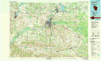
~ Eau Claire WI topo map, 1:100000 scale, 30 X 60 Minute, Historical, 1985, updated 1989
Eau Claire, Wisconsin, USGS topographic map dated 1985.
Includes geographic coordinates (latitude and longitude). This topographic map is suitable for hiking, camping, and exploring, or framing it as a wall map.
Printed on-demand using high resolution imagery, on heavy weight and acid free paper, or alternatively on a variety of synthetic materials.
Topos available on paper, Waterproof, Poly, or Tyvek. Usually shipping rolled, unless combined with other folded maps in one order.
- Product Number: USGS-5309746
- Free digital map download (high-resolution, GeoPDF): Eau Claire, Wisconsin (file size: 17 MB)
- Map Size: please refer to the dimensions of the GeoPDF map above
- Weight (paper map): ca. 55 grams
- Map Type: POD USGS Topographic Map
- Map Series: HTMC
- Map Verison: Historical
- Cell ID: 67455
- Scan ID: 803106
- Imprint Year: 1989
- Woodland Tint: Yes
- Photo Inspection Year: 1988
- Aerial Photo Year: 1980
- Edit Year: 1985
- Datum: NAD27
- Map Projection: Universal Transverse Mercator
- Map published by United States Geological Survey
- Map Language: English
- Scanner Resolution: 508 dpi
- Map Cell Name: Eau Claire
- Grid size: 30 X 60 Minute
- Date on map: 1985
- Map Scale: 1:100000
- Geographical region: Wisconsin, United States
Neighboring Maps:
All neighboring USGS topo maps are available for sale online at a variety of scales.
Spatial coverage:
Topo map Eau Claire, Wisconsin, covers the geographical area associated the following places:
- Rodell - Hay Creek - Pine Grove - Norma - Rusk - Seymour - Countryside Manor Mobile Home Park - Brackett - Cadott - Pinehurst - Downsville - Altoona - Anson - Elk Mound - Wilson - Boyd - Requa - Lima - Allen - Old Albertville - Fall Creek - Mount Hope Corners - Chippewa Falls - Lake Wissota - Eau Claire - Laneville - Bateman - Cedar Falls - Nelsonville (historical) - Red Cedar - Colfax - Bluff Crest Mobile Home Park - Albertville - Maples Mobile Home Park - Rock Falls - Green Acres - Foster - Tainter Lake - Caryville - Augusta - Camino Mobile Home Park - Cleghorn - Strum - Putnam Heights - Durand - Berghs Mobile Home Park - Hale Corner - Terrace Hill - Irvington - Huber Mobile Home Park - Price - Levis - Union - Eleva - Shawtown - Menomonie Junction - Villa Diann Mobile Home Park - Pine Edge Mobile Home Park - Falls City - Menominee - Oak Ridge Village Mobile Home Park - Oak Grove (historical) - Truax - Lufkin - Osseo - Lake Hallie - North Menomonie - Mondovi - Hallie - Edson - Hillcrest Estates Mobile Home Park - Ludington - Meridean - Springdale (historical) - Irvine - Howard - Dunnville - Old Tyrone (historical) - Tarrant - Nix Corner
- Map Area ID: AREA4544.5-92-91
- Northwest corner Lat/Long code: USGSNW45-92
- Northeast corner Lat/Long code: USGSNE45-91
- Southwest corner Lat/Long code: USGSSW44.5-92
- Southeast corner Lat/Long code: USGSSE44.5-91
- Northern map edge Latitude: 45
- Southern map edge Latitude: 44.5
- Western map edge Longitude: -92
- Eastern map edge Longitude: -91


