
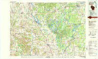
~ Bloomer WI topo map, 1:100000 scale, 30 X 60 Minute, Historical, 1980, updated 1980
Bloomer, Wisconsin, USGS topographic map dated 1980.
Includes geographic coordinates (latitude and longitude). This topographic map is suitable for hiking, camping, and exploring, or framing it as a wall map.
Printed on-demand using high resolution imagery, on heavy weight and acid free paper, or alternatively on a variety of synthetic materials.
Topos available on paper, Waterproof, Poly, or Tyvek. Usually shipping rolled, unless combined with other folded maps in one order.
- Product Number: USGS-5309742
- Free digital map download (high-resolution, GeoPDF): Bloomer, Wisconsin (file size: 17 MB)
- Map Size: please refer to the dimensions of the GeoPDF map above
- Weight (paper map): ca. 55 grams
- Map Type: POD USGS Topographic Map
- Map Series: HTMC
- Map Verison: Historical
- Cell ID: 67152
- Scan ID: 801406
- Imprint Year: 1980
- Woodland Tint: Yes
- Aerial Photo Year: 1976
- Edit Year: 1980
- Datum: NAD27
- Map Projection: Universal Transverse Mercator
- Map published by United States Geological Survey
- Map Language: English
- Scanner Resolution: 508 dpi
- Map Cell Name: Bloomer
- Grid size: 30 X 60 Minute
- Date on map: 1980
- Map Scale: 1:100000
- Geographical region: Wisconsin, United States
Neighboring Maps:
All neighboring USGS topo maps are available for sale online at a variety of scales.
Spatial coverage:
Topo map Bloomer, Wisconsin, covers the geographical area associated the following places:
- Baxter - Wickware - Chetek - Cornell - Sumner - Drywood - Bruce - Anderson Trailer Court - Flambeau Estates - New Auburn - Horseman - Cobban - Eagleton - Lehigh - Ladysmith - Tilden - Thornapple - Crescent - Lakeshore Trailer Park - Bloomer - Riverview Trailer Park - Dallas - Apollonia - Cameron - Island Lake - Prairie Farm - Arnold - Poskin - Eagle Point - Wheeler - Rivers Edge - Colburn - Weyerhaeuser - Sand Creek - Norton - Jim Falls - Camelot Mobile Home Park - Ridgeland - Holcombe - Strickland - Canton - Hillsdale - Barron - Highway Eight Trailer Court - Willow Lane Trailer Park - Conrath - Port Arthur
- Map Area ID: AREA45.545-92-91
- Northwest corner Lat/Long code: USGSNW45.5-92
- Northeast corner Lat/Long code: USGSNE45.5-91
- Southwest corner Lat/Long code: USGSSW45-92
- Southeast corner Lat/Long code: USGSSE45-91
- Northern map edge Latitude: 45.5
- Southern map edge Latitude: 45
- Western map edge Longitude: -92
- Eastern map edge Longitude: -91


