
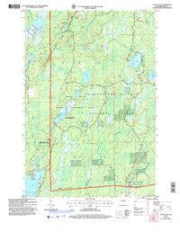
~ Gates Lake WI topo map, 1:24000 scale, 7.5 X 7.5 Minute, Historical, 2005, updated 2006
Gates Lake, Wisconsin, USGS topographic map dated 2005.
Includes geographic coordinates (latitude and longitude). This topographic map is suitable for hiking, camping, and exploring, or framing it as a wall map.
Printed on-demand using high resolution imagery, on heavy weight and acid free paper, or alternatively on a variety of synthetic materials.
Topos available on paper, Waterproof, Poly, or Tyvek. Usually shipping rolled, unless combined with other folded maps in one order.
- Product Number: USGS-5305318
- Free digital map download (high-resolution, GeoPDF): Gates Lake, Wisconsin (file size: 11 MB)
- Map Size: please refer to the dimensions of the GeoPDF map above
- Weight (paper map): ca. 55 grams
- Map Type: POD USGS Topographic Map
- Map Series: HTMC
- Map Verison: Historical
- Cell ID: 16961
- Scan ID: 700144
- Imprint Year: 2006
- Woodland Tint: Yes
- Aerial Photo Year: 1999
- Datum: NAD83
- Map Projection: Universal Transverse Mercator
- Map published by United States Forest Service
- Map Language: English
- Scanner Resolution: 508 dpi
- Map Cell Name: Gates Lake
- Grid size: 7.5 X 7.5 Minute
- Date on map: 2005
- Map Scale: 1:24000
- Geographical region: Wisconsin, United States
Neighboring Maps:
All neighboring USGS topo maps are available for sale online at a variety of scales.
Spatial coverage:
Topo map Gates Lake, Wisconsin, covers the geographical area associated the following places:
- Schmuland Flowage - Spur Lake - Gates Lake - Beaver Lake - Lower Squaw Creek Flowage - Solberg Lake County Park - Solberg Lake - Hicks Landing - Squaw Creek Flowage 6 - Lower Squaw Creek Waterfowl Area - Sailor Lake - Hogsback Springs - Squaw Creek D31.18 Dam - Dalrymple Creek - Schmuland Waterfowl Area - Squaw Creek Wildlife Flowage 2WP2459 Dam - Sailor Lake Recreation Site - Nichols Lake - Hesher Creek - Upper Squaw Creek Waterfowl Area
- Map Area ID: AREA45.87545.75-90.375-90.25
- Northwest corner Lat/Long code: USGSNW45.875-90.375
- Northeast corner Lat/Long code: USGSNE45.875-90.25
- Southwest corner Lat/Long code: USGSSW45.75-90.375
- Southeast corner Lat/Long code: USGSSE45.75-90.25
- Northern map edge Latitude: 45.875
- Southern map edge Latitude: 45.75
- Western map edge Longitude: -90.375
- Eastern map edge Longitude: -90.25


