
~ Chincoteague VA topo map, 1:250000 scale, 1 X 2 Degree, Historical, 1984, updated 1984
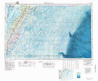
Chincoteague, Virginia, USGS topographic map dated 1984.
Includes geographic coordinates (latitude and longitude). This topographic map is suitable for hiking, camping, and exploring, or framing it as a wall map.
Printed on-demand using high resolution imagery, on heavy weight and acid free paper, or alternatively on a variety of synthetic materials.
Topos available on paper, Waterproof, Poly, or Tyvek. Usually shipping rolled, unless combined with other folded maps in one order.
- Product Number: USGS-5304202
- Free digital map download (high-resolution, GeoPDF): Chincoteague, Virginia (file size: 26 MB)
- Map Size: please refer to the dimensions of the GeoPDF map above
- Weight (paper map): ca. 55 grams
- Map Type: POD USGS Topographic Map
- Map Series: HTMC
- Map Verison: Historical
- Cell ID: 68715
- Scan ID: 189245
- Imprint Year: 1984
- Woodland Tint: Yes
- Visual Version Number: 1
- Edit Year: 1984
- Datum: NAD27
- Map Projection: Transverse Mercator
- Map published by United States Geological Survey
- Map Language: English
- Scanner Resolution: 600 dpi
- Map Cell Name: Chincoteague
- Grid size: 1 X 2 Degree
- Date on map: 1984
- Map Scale: 1:250000
- Geographical region: Virginia, United States
Neighboring Maps:
All neighboring USGS topo maps are available for sale online at a variety of scales.
Spatial coverage:
Topo map Chincoteague, Virginia, covers the geographical area associated the following places:
- Nelson - Lecato - Savageville - Weirwood - Clearview - Locust Mount - Rue - Culls - Collins Estates - Captains Cove - Tangier - Black Point Landing - Solitude Trails - Trower - Indian Hammock - Red Bank - Wardtown - Mount Zion - Birch Town - Parker Landing - Nassawadox - Nasa Mobile Home Park - The Meadows - Franktown - Savage Town - Deerfield Estates - Onancock - Kiptopeke - Bayford - Nelsonia - Pennyville - Reedtown - Sinnickson - Craddockville - Hallwood - Cedar View - Wachapreague - Deep Hole - Cardinal Estates - Mappsburg - Red Bank - Harborton - Horntown - Makemie Park - Hopkins - Guilford - Boston - East Point - James Crossroads - Dreamland Mobile Home Park - Hideaway Cove - Daugherty Town - Cats Bridge - Simpkins - Keller - Onley - Locksville - Stewarts Landing - Peaceful Shores - Wattsville - Parsonville - Martins Siding - Howard (historical) - Oyster - Ward - Shelltown - Poulson - Crockett Town - Oak Hall - Woodland Park Mobile Home Park - Vaucluse Shores - Greenbush - Magotha - Hadlock - Tasley - Old Trower - Brownsville (historical) - Little Salisbury - Sheps End - Shadyside - Deep Creek - Middletown - Smithville - Allentown - Westerhouse Woods - Greta (historical) - Clam - South Chesconessex - Chincoteague - Sackertown - Mutton Hunk - Dalbys - Harbour Point - Johnson Cove - Bayside - Fairview - Eastville - Hopeton - Bayleys Neck Farm - Highland Heights
- Map Area ID: AREA3837-76-74
- Northwest corner Lat/Long code: USGSNW38-76
- Northeast corner Lat/Long code: USGSNE38-74
- Southwest corner Lat/Long code: USGSSW37-76
- Southeast corner Lat/Long code: USGSSE37-74
- Northern map edge Latitude: 38
- Southern map edge Latitude: 37
- Western map edge Longitude: -76
- Eastern map edge Longitude: -74


