
~ Chincoteague VA topo map, 1:250000 scale, 1 X 2 Degree, Historical, 1984, updated 1984
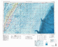
Chincoteague, Virginia, USGS topographic map dated 1984.
Includes geographic coordinates (latitude and longitude). This topographic map is suitable for hiking, camping, and exploring, or framing it as a wall map.
Printed on-demand using high resolution imagery, on heavy weight and acid free paper, or alternatively on a variety of synthetic materials.
Topos available on paper, Waterproof, Poly, or Tyvek. Usually shipping rolled, unless combined with other folded maps in one order.
- Product Number: USGS-5304200
- Free digital map download (high-resolution, GeoPDF): Chincoteague, Virginia (file size: 26 MB)
- Map Size: please refer to the dimensions of the GeoPDF map above
- Weight (paper map): ca. 55 grams
- Map Type: POD USGS Topographic Map
- Map Series: HTMC
- Map Verison: Historical
- Cell ID: 68715
- Scan ID: 189244
- Imprint Year: 1984
- Woodland Tint: Yes
- Visual Version Number: 2
- Edit Year: 1984
- Datum: NAD27
- Map Projection: Transverse Mercator
- Map published by United States Geological Survey
- Map Language: English
- Scanner Resolution: 600 dpi
- Map Cell Name: Chincoteague
- Grid size: 1 X 2 Degree
- Date on map: 1984
- Map Scale: 1:250000
- Geographical region: Virginia, United States
Neighboring Maps:
All neighboring USGS topo maps are available for sale online at a variety of scales.
Spatial coverage:
Topo map Chincoteague, Virginia, covers the geographical area associated the following places:
- Beverly - Parker Landing - Miona - Shelltown - Eastville - Nasa Mobile Home Park - Franktown - Pleasant Cove Village - Flag Pond Landing - Guilford - Coocheyville - Cashville - Bulls Landing - Locustville - Pungoteague - Bayford - Red Hill - Reedtown - Red Bank - Lecato - South Point - Pine Ridge Mobile Home Park - Ward - Mears Station - Ticktown - Broadwater - Birch Town - Justisville - Culls - Jamesville - Clam - Crockett Town - Grotons - Solitude Trails - Lawsonia - Craddockville - Old Neck Landing - Cedar View - Fairview - Seaview - Pastoria - Daugherty Town - Johnson Cove - Savage Town - South Chesconessex - High Woods - Nelson - Modest Town - Hungars Point - Mappsville - Painter - Middlesex - Nelsonia - Deerfield Estates - Sanford - Vaucluse Shores - Metompkin - Locust Mount - Davis Wharf - Shad Landing - Pennyville - Saxis - Shields - Horntown - Bayside - Bridgetown - Smith Beach - Belle Haven - Mount Nebo - Weirwood - Collins Estates - Highland Heights - Bobtown - Oakland Park - Kendall Grove Estates - Little Johnsontown - Lee Mont - Groton Town - Macedonia - Harbour Point - Deep Hole - Exmore - Cash Corner - Trower - Oyster - Westerhouse Woods - Atlantic - Onancock - Tyler - East Point - Boston - Cheapside - Clearview - Willis Wharf - Hopeton - Johnsontown - Gargatha - Stewarts Landing - Hideaway Cove - Horsey
- Map Area ID: AREA3837-76-74
- Northwest corner Lat/Long code: USGSNW38-76
- Northeast corner Lat/Long code: USGSNE38-74
- Southwest corner Lat/Long code: USGSSW37-76
- Southeast corner Lat/Long code: USGSSE37-74
- Northern map edge Latitude: 38
- Southern map edge Latitude: 37
- Western map edge Longitude: -76
- Eastern map edge Longitude: -74


