
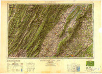
~ Charlottesville VA topo map, 1:250000 scale, 1 X 2 Degree, Historical, 1949, updated 1949
Charlottesville, Virginia, USGS topographic map dated 1949.
Includes geographic coordinates (latitude and longitude). This topographic map is suitable for hiking, camping, and exploring, or framing it as a wall map.
Printed on-demand using high resolution imagery, on heavy weight and acid free paper, or alternatively on a variety of synthetic materials.
Topos available on paper, Waterproof, Poly, or Tyvek. Usually shipping rolled, unless combined with other folded maps in one order.
- Product Number: USGS-5304198
- Free digital map download (high-resolution, GeoPDF): Charlottesville, Virginia (file size: 12 MB)
- Map Size: please refer to the dimensions of the GeoPDF map above
- Weight (paper map): ca. 55 grams
- Map Type: POD USGS Topographic Map
- Map Series: HTMC
- Map Verison: Historical
- Cell ID: 68712
- Scan ID: 707272
- Imprint Year: 1949
- Woodland Tint: Yes
- Aerial Photo Year: 1945
- Datum: NAD27
- Map Projection: Transverse Mercator
- Shaded Relief map: Yes
- Map published by United States Army
- Map Language: English
- Scanner Resolution: 508 dpi
- Map Cell Name: Charlottesville
- Grid size: 1 X 2 Degree
- Date on map: 1949
- Map Scale: 1:250000
- Geographical region: Virginia, United States
Neighboring Maps:
All neighboring USGS topo maps are available for sale online at a variety of scales.
Spatial coverage:
Topo map Charlottesville, Virginia, covers the geographical area associated the following places:
- Bell Haven - Happy Creek - Maurertown - Harpertown - Saumsville - Trevilians - Stemphleytown - Wymer - Red Mills - Faulkner - Rockland - Bentonville - Airport Acres - Loch Leigh - Criglersville - Townwood - Mount Crawford - Glady - Hiser (historical) - Meriwether Hill - Weese - Graves Mill - Rose Hill Estates - Charlottesville - Mount Jackson - Kings Crossing - Hopeville - Limeton - Fairview - Stanley - Loftlands Wood - Piedmont - Craigsville - Hensel Stone Woods - South Jackson - Gilbert - Vaughn - Front Royal - Masonville - Raywood - Tryme - Paulington (historical) - Campbell - Royal Village - Shadwell - Alonzaville - Camellia Garden - Goods Mill - Korea - Boyer - Advance Mills Village - Cobham Park - Round Hill - Oakwood - Petersburg - Edinburg - Greenbriar Heights - Camelot - Lake Hills - Revercombs Corner - Hickory Ridge - Peach Grove (historical) - Advance Mills - Brookwood - Blue Ridge Acres - Terrybrook - Huntington Village - Duet - Evenwood - Palo Alto - Oaklawn - Coffmantown - Berrytown - Battle Creek - Grove Hill - Milton - Burner - Jerome - Ladd - Loch Linden - Centerville - Cedarmere - Old Furnace (historical) - Intersections - Georgetown - Stonehenge - Trimmers Crossing - Aylor - Rediviva - Beaver Hill Mobile Home Park - Everettsville - Oakland - Stribling Springs - Riverrun - Lochridge - Mill Run - Dale Enterprise - Lost City - Rushville - Summerfield
- Map Area ID: AREA3938-80-78
- Northwest corner Lat/Long code: USGSNW39-80
- Northeast corner Lat/Long code: USGSNE39-78
- Southwest corner Lat/Long code: USGSSW38-80
- Southeast corner Lat/Long code: USGSSE38-78
- Northern map edge Latitude: 39
- Southern map edge Latitude: 38
- Western map edge Longitude: -80
- Eastern map edge Longitude: -78


