
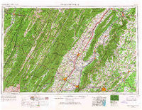
~ Charlottesville VA topo map, 1:250000 scale, 1 X 2 Degree, Historical, 1956, updated 1966
Charlottesville, Virginia, USGS topographic map dated 1956.
Includes geographic coordinates (latitude and longitude). This topographic map is suitable for hiking, camping, and exploring, or framing it as a wall map.
Printed on-demand using high resolution imagery, on heavy weight and acid free paper, or alternatively on a variety of synthetic materials.
Topos available on paper, Waterproof, Poly, or Tyvek. Usually shipping rolled, unless combined with other folded maps in one order.
- Product Number: USGS-5304194
- Free digital map download (high-resolution, GeoPDF): Charlottesville, Virginia (file size: 20 MB)
- Map Size: please refer to the dimensions of the GeoPDF map above
- Weight (paper map): ca. 55 grams
- Map Type: POD USGS Topographic Map
- Map Series: HTMC
- Map Verison: Historical
- Cell ID: 68712
- Scan ID: 189242
- Imprint Year: 1966
- Woodland Tint: Yes
- Edit Year: 1965
- Field Check Year: 1956
- Datum: Unstated
- Map Projection: Transverse Mercator
- Map published by United States Geological Survey
- Map Language: English
- Scanner Resolution: 600 dpi
- Map Cell Name: Charlottesville
- Grid size: 1 X 2 Degree
- Date on map: 1956
- Map Scale: 1:250000
- Geographical region: Virginia, United States
Neighboring Maps:
All neighboring USGS topo maps are available for sale online at a variety of scales.
Spatial coverage:
Topo map Charlottesville, Virginia, covers the geographical area associated the following places:
- Boston - Shenandoah River Lakes - Fairview - Applewood - Valleyburgh - Stultz Mill - Oakpark - McCoy - Etlan - Frays Mountain Estates - Woodland Park - Edinburg - Cross Keys - Marble Valley - Cedarmere - Broadway - Lasley (historical) - Laurel Mills - Fairview Acres - Hessian Hills - West Leigh - Meadowbrook Heights - Cardova - Annex - Greenbriar Heights - Eggbornsville - Deerwood - Aylor - Getz Corner - Key (historical) - Beverly - McDowell - Dooms - Upper Pocosin - Newport - Red Mills - Kings Crossing - Winston - Fletcher Mill - Stuarts Draft - Royal Village - Shenandoah Forest - Crossroads - Shanklin (historical) - Massies Corner - Spring Creek - Verona - Dawsons Shop (historical) - Stringtown (historical) - Deer Haven - Hamburg - Petersburg - Simmons Gap - Dahmer - Scrabble - Harper - Stony Point - Country Green - Palo Alto - Detrick - Roman - Apple Mountain Lake West - Dunlora Plantation - Pansy - Sleepy Hollow Mobile Home Park - Catalpa Hills - Royal Acres - Lynnwood - Cash Corner - Little Clover Hill - Mulberry Greens - Stony Man - Hackleys Crossroad - Amicus - Milton - Thelma - Lilly - Birnam Wood - North Pines - Little Italy - Green Mount - Findley (historical) - Selma - Bedford Hills - Masonville - Tanners - Reager - Whitlock - Compton - Briarwood - Saint George - Macksville - Hill and Dale - Springfield - Royal View Estates - Gage - Peach Grove (historical) - Bolar - Berkeley - Howellsville
- Map Area ID: AREA3938-80-78
- Northwest corner Lat/Long code: USGSNW39-80
- Northeast corner Lat/Long code: USGSNE39-78
- Southwest corner Lat/Long code: USGSSW38-80
- Southeast corner Lat/Long code: USGSSE38-78
- Northern map edge Latitude: 39
- Southern map edge Latitude: 38
- Western map edge Longitude: -80
- Eastern map edge Longitude: -78


