
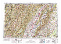
~ Charlottesville VA topo map, 1:250000 scale, 1 X 2 Degree, Historical, 1956, updated 1977
Charlottesville, Virginia, USGS topographic map dated 1956.
Includes geographic coordinates (latitude and longitude). This topographic map is suitable for hiking, camping, and exploring, or framing it as a wall map.
Printed on-demand using high resolution imagery, on heavy weight and acid free paper, or alternatively on a variety of synthetic materials.
Topos available on paper, Waterproof, Poly, or Tyvek. Usually shipping rolled, unless combined with other folded maps in one order.
- Product Number: USGS-5304190
- Free digital map download (high-resolution, GeoPDF): Charlottesville, Virginia (file size: 24 MB)
- Map Size: please refer to the dimensions of the GeoPDF map above
- Weight (paper map): ca. 55 grams
- Map Type: POD USGS Topographic Map
- Map Series: HTMC
- Map Verison: Historical
- Cell ID: 68712
- Scan ID: 189240
- Imprint Year: 1977
- Woodland Tint: Yes
- Visual Version Number: 2
- Edit Year: 1965
- Field Check Year: 1956
- Datum: Unstated
- Map Projection: Transverse Mercator
- Map published by United States Geological Survey
- Map Language: English
- Scanner Resolution: 600 dpi
- Map Cell Name: Charlottesville
- Grid size: 1 X 2 Degree
- Date on map: 1956
- Map Scale: 1:250000
- Geographical region: Virginia, United States
Neighboring Maps:
All neighboring USGS topo maps are available for sale online at a variety of scales.
Spatial coverage:
Topo map Charlottesville, Virginia, covers the geographical area associated the following places:
- Commonwealth - West Augusta - Edom - East Dailey - Front Royal Junction - Brownsville - Nortonsville - Mount Olive - Stadium Road Residence Area - Spring View - Shenandoah Homesteads Project - Griffinsburg - Williamsville - Switch Back - Weyers Cave - Forestville - Chapel Hills - Ladd - Oaklawn - Mount Airy - O'Neal - Edinburg - Bethel - Ednam Village - Gilbert Heights - Little Baltimore - Hunters Hall - Mill Gap - Midland - Lake Acres - Mount Pisgah - Pineville - Pleasant Valley - Rushville - Waylandsburg - Mill Run - Foothill Village - Greenbriar Heights - Laneville - Hebron - Fourway - Oak Grove - Hotchkiss - Cash Corner - Midway - Rochelle - Country Green - The Meadows - Vawter Corner - Circleville - Wilson Heights - Novum - Oak Hill Mobile Home Park - Harmony - Eggbornsville - Monterey Orchards - Oakwood - Getz Corner - Teterton - Fort Defiance - Weyburn (historical) - Crozet - Shenandoah River Lakes - Viewtown - Owensville - Mount Solon - Fame - Inglewood - Wolftown - Mountain View - Woodbrook - Repton Mills - Belmont - Madrid - White Hall - Stemphleytown - Burnley - Harriston - Meadowbrook Heights - Penn Laird - Monkeytown - Palo Alto - Clearview Knolls - Barren Ridge - Zenda - The Meadows - Westover - Mallard Lake - Browntown - Lacey Spring - Cresthill - Minnehaha Springs - Harperton - Pelton - Harding - Skidmore (historical) - Greenville - Timber Ridge - Massanetta Springs - Deer Haven
- Map Area ID: AREA3938-80-78
- Northwest corner Lat/Long code: USGSNW39-80
- Northeast corner Lat/Long code: USGSNE39-78
- Southwest corner Lat/Long code: USGSSW38-80
- Southeast corner Lat/Long code: USGSSE38-78
- Northern map edge Latitude: 39
- Southern map edge Latitude: 38
- Western map edge Longitude: -80
- Eastern map edge Longitude: -78


