
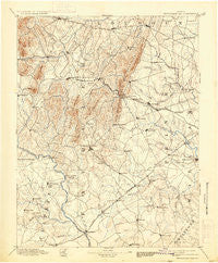
~ Thorofare Gap VA topo map, 1:125000 scale, 30 X 30 Minute, Historical, 1894, updated 1933
Thorofare Gap, Virginia, USGS topographic map dated 1894.
Includes geographic coordinates (latitude and longitude). This topographic map is suitable for hiking, camping, and exploring, or framing it as a wall map.
Printed on-demand using high resolution imagery, on heavy weight and acid free paper, or alternatively on a variety of synthetic materials.
Topos available on paper, Waterproof, Poly, or Tyvek. Usually shipping rolled, unless combined with other folded maps in one order.
- Product Number: USGS-5304146
- Free digital map download (high-resolution, GeoPDF): Thorofare Gap, Virginia (file size: 7 MB)
- Map Size: please refer to the dimensions of the GeoPDF map above
- Weight (paper map): ca. 55 grams
- Map Type: POD USGS Topographic Map
- Map Series: HTMC
- Map Verison: Historical
- Cell ID: 66776
- Scan ID: 189198
- Imprint Year: 1933
- Survey Year: 1887
- Datum: Unstated
- Map Projection: Polyconic
- Map published by United States Geological Survey
- Map Language: English
- Scanner Resolution: 600 dpi
- Map Cell Name: Thorofare Gap
- Grid size: 30 X 30 Minute
- Date on map: 1894
- Map Scale: 1:125000
- Geographical region: Virginia, United States
Neighboring Maps:
All neighboring USGS topo maps are available for sale online at a variety of scales.
Spatial coverage:
Topo map Thorofare Gap, Virginia, covers the geographical area associated the following places:
- Aldie - Rolling Hills - Lawnvale Estates - Piedmont Heights - Countryside Estates - Bull Run East - Iron Gate - Rixlew - Stafford Station - Waterloo - South Wales - Catalpa - Carolandville - Woolsey - Sunny Bank (historical) - Brent Turf Acres - Old Tavern - Morgansburg - Hickory Grove - Balls Mill - Bull Run Mountain Estates - Old Field Estates - Dudie - Morgantown - Alwington - Sunny Knoll - Bethel - Magee - Linton Hall - German - Gilberts Corner - Rectortown - Cliff Mills - Stewartown - Tacketts Mill - Brandy Station - Churchill - Liberty - Aquia Creek Estates - Carlyle Station - Crescent - Bunker Hill - Waterfall - Walnut Ridge - Westgate - Greenwich - Butler - Bataan Village - Airlie - Bleak - The Sage - Weimertown - Saint Stephens - Doddstown - Coverstone - Erinbrook - Rock Hill Estates - Germantown - Kerfoot - Eustacestown - Catlett - Zulla - Rosstown - Rocky Run - Crestwood Village - Hume - Vernon Mills - Millbrook - Lakeland - Woodlawn Farms - Delaplane - Covingtons Corner - Marshall - Palmers Crossroads - Hillwood Park Mobile Home Park - Olde South Estates - Warrenton - Bowmantown - Jacksontown - Browns Corner - Kennard Ridge - Snow Hill - Botha - Wellington - Rock Hill Manors - Turkey Run - Amissville - Casanova - Lake Arrowhead - Ashville - Foster Fork - Landmark - Twin Oaks - Oak Shade - Long Level Estates - Mountainview - Bristersburg - Springfield - Bristow - Belvoir
- Map Area ID: AREA3938.5-78-77.5
- Northwest corner Lat/Long code: USGSNW39-78
- Northeast corner Lat/Long code: USGSNE39-77.5
- Southwest corner Lat/Long code: USGSSW38.5-78
- Southeast corner Lat/Long code: USGSSE38.5-77.5
- Northern map edge Latitude: 39
- Southern map edge Latitude: 38.5
- Western map edge Longitude: -78
- Eastern map edge Longitude: -77.5


