
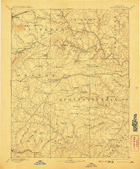
~ Spottsylvania VA topo map, 1:125000 scale, 30 X 30 Minute, Historical, 1892, updated 1907
Spottsylvania, Virginia, USGS topographic map dated 1892.
Includes geographic coordinates (latitude and longitude). This topographic map is suitable for hiking, camping, and exploring, or framing it as a wall map.
Printed on-demand using high resolution imagery, on heavy weight and acid free paper, or alternatively on a variety of synthetic materials.
Topos available on paper, Waterproof, Poly, or Tyvek. Usually shipping rolled, unless combined with other folded maps in one order.
- Product Number: USGS-5304110
- Free digital map download (high-resolution, GeoPDF): Spottsylvania, Virginia (file size: 7 MB)
- Map Size: please refer to the dimensions of the GeoPDF map above
- Weight (paper map): ca. 55 grams
- Map Type: POD USGS Topographic Map
- Map Series: HTMC
- Map Verison: Historical
- Cell ID: 66673
- Scan ID: 189171
- Imprint Year: 1907
- Survey Year: 1887
- Datum: Unstated
- Map Projection: Unstated
- Map published by United States Geological Survey
- Map Language: English
- Scanner Resolution: 600 dpi
- Map Cell Name: Spotsylvania
- Grid size: 30 X 30 Minute
- Date on map: 1892
- Map Scale: 1:125000
- Geographical region: Virginia, United States
Neighboring Maps:
All neighboring USGS topo maps are available for sale online at a variety of scales.
Spatial coverage:
Topo map Spottsylvania, Virginia, covers the geographical area associated the following places:
- Dodds Corner - Deep Run - Goldvein - Logan - Roseville Plantation - Gauntlet Estates - Hartlake Estates - Keatwood - Woodridge - Belmont - Massaponax - Maple Grove Estates - Richardsville South - Water Edge Estates - Blades Corner - Cedar Knolls Estates - Tacketts Farm - Ann Wrights Corner - Parker - Windsor Forest - Berea Plantation - Todds Tavern - Rhoadesville - Peach Lawn - Batna - Walden Ten - Concord Estates - Childs Cove - Flat Run - England Run - McHenry - Seven Lakes - Meadows of Culpeper - Stony Hill Estates - Pine View - Carrico - Cookstown - Culpeper - Stefaniga - Mansfield Manor - Long Branch - Spotsylvania Courthouse - Berea - Tatum - Carrera Estates - Rivergate - Prince Dominion - Frank Martin Farms - Thornburg - Dunavant - Beverly Estates - Kirk O'Cliff - Stanards Mill - Jones - Whitetown - Davis Corner - Crestwood - Mars Mobile Home Park - Manor Wood Estates - The Preserve on Aquia Creek - Thornhill - Hartwood - Willowmere - Sherwood Estates - English Hills - Hartwood Village - Mine Run - Stafford Lakes Village - Mansfield (historical) - Harris (historical) - Valhalla - Christy Farm - Skidmore Corner - Diamond Park - Arcadia - Berea Estates - Everona - Blantons - True Blue - Cardinal Forest - Mastins Corner - Rosedale - Chesterfield - Roseville - The Blake Farm - Brokenburg - Rosewood Estates - Lakeland Forest - Paynes Corner - Mount Pleasant - Holly Corners - The Cascades - Glendie - Lanes Corner - Seymour Knolls - Cuzco (historical) - Wilderness - Ellisville - Whitestone - Verdiersville
- Map Area ID: AREA38.538-78-77.5
- Northwest corner Lat/Long code: USGSNW38.5-78
- Northeast corner Lat/Long code: USGSNE38.5-77.5
- Southwest corner Lat/Long code: USGSSW38-78
- Southeast corner Lat/Long code: USGSSE38-77.5
- Northern map edge Latitude: 38.5
- Southern map edge Latitude: 38
- Western map edge Longitude: -78
- Eastern map edge Longitude: -77.5


