
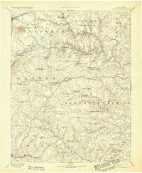
~ Spotsylvania VA topo map, 1:125000 scale, 30 X 30 Minute, Historical, 1892, updated 1932
Spotsylvania, Virginia, USGS topographic map dated 1892.
Includes geographic coordinates (latitude and longitude). This topographic map is suitable for hiking, camping, and exploring, or framing it as a wall map.
Printed on-demand using high resolution imagery, on heavy weight and acid free paper, or alternatively on a variety of synthetic materials.
Topos available on paper, Waterproof, Poly, or Tyvek. Usually shipping rolled, unless combined with other folded maps in one order.
- Product Number: USGS-5304102
- Free digital map download (high-resolution, GeoPDF): Spotsylvania, Virginia (file size: 6 MB)
- Map Size: please refer to the dimensions of the GeoPDF map above
- Weight (paper map): ca. 55 grams
- Map Type: POD USGS Topographic Map
- Map Series: HTMC
- Map Verison: Historical
- Cell ID: 66673
- Scan ID: 189173
- Imprint Year: 1932
- Survey Year: 1887
- Datum: Unstated
- Map Projection: Polyconic
- Map published by United States Geological Survey
- Map Language: English
- Scanner Resolution: 600 dpi
- Map Cell Name: Spotsylvania
- Grid size: 30 X 30 Minute
- Date on map: 1892
- Map Scale: 1:125000
- Geographical region: Virginia, United States
Neighboring Maps:
All neighboring USGS topo maps are available for sale online at a variety of scales.
Spatial coverage:
Topo map Spotsylvania, Virginia, covers the geographical area associated the following places:
- Old Banks - Seymour Knolls - Tacketts Farm - Holladay - Wallaces Corner - Glendie - Berea Plantation - Marye - Mansfield Manor - Winslow Heights - Rhoadesville - Harris (historical) - Pine View - McHenry - Royal Hills Estates - Golden Hills - Lewiston - Foxwood Estates - Thornburg - Cedar Knolls Estates - Stony Hill Estates - Five Mile Fork - Laurelwood - Cool River - Chesterfield - Kellys Ford - Gold Dale - Sherwood Estates - Penneys Crossroad - Milburn Estates - Cannon Knolls - Hartwood Village - Richland Forest - Nora Park - Davis Corner - Woodridge - Post Oak - Alsop - Chancellor - Arcadia - Sherwood Forest - Hoys Way - England Run - Skidmore Corner - Kings Grant - Goldvein - Silver Hill - The Preserve on Aquia Creek - Levy - Todds Tavern - Mansefield - Cedon - Rosewood Estates - Seven Lakes - Ivyglen - Peach Lawn - Smiths Mill - Nellie Estates - Nancy Wrights Corner - Spotsylvania - Crown Manor - Wallers Corner - Heflin - Wellington Chase on the Rappahannock - Diamond Park - Mansfield (historical) - Red Hill - Storck - Mineral - Meadows Park - Plum Tree - Crestwood - Bells Crossroad - Olivers Corner - Monrovia - Holly Corners - Prince Dominion - English Hills - Country Wood Estates - Leavells - Lakeland Forest - Richardsville South - Georgetown West - Holly Corner Estates - Childs Cove - Ryland Corner - Parker - Belle Parc - Dodds Corner - Berry Hill Estates - Tatum - Mastins Corner - White Owl Landing - Frank Martin Farms - Mount Holly - Hartwood - Stanards Mill - Cropp - Carrico - Chesterwood
- Map Area ID: AREA38.538-78-77.5
- Northwest corner Lat/Long code: USGSNW38.5-78
- Northeast corner Lat/Long code: USGSNE38.5-77.5
- Southwest corner Lat/Long code: USGSSW38-78
- Southeast corner Lat/Long code: USGSSE38-77.5
- Northern map edge Latitude: 38.5
- Southern map edge Latitude: 38
- Western map edge Longitude: -78
- Eastern map edge Longitude: -77.5


