
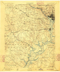
~ Mt Vernon VA topo map, 1:125000 scale, 30 X 30 Minute, Historical, 1894, updated 1909
Mt Vernon, Virginia, USGS topographic map dated 1894.
Includes geographic coordinates (latitude and longitude). This topographic map is suitable for hiking, camping, and exploring, or framing it as a wall map.
Printed on-demand using high resolution imagery, on heavy weight and acid free paper, or alternatively on a variety of synthetic materials.
Topos available on paper, Waterproof, Poly, or Tyvek. Usually shipping rolled, unless combined with other folded maps in one order.
- Product Number: USGS-5304026
- Free digital map download (high-resolution, GeoPDF): Mt Vernon, Virginia (file size: 7 MB)
- Map Size: please refer to the dimensions of the GeoPDF map above
- Weight (paper map): ca. 55 grams
- Map Type: POD USGS Topographic Map
- Map Series: HTMC
- Map Verison: Historical
- Cell ID: 320671
- Scan ID: 189083
- Imprint Year: 1909
- Survey Year: 1888
- Datum: Unstated
- Map Projection: Unstated
- Map published by United States Geological Survey
- Map Language: English
- Scanner Resolution: 600 dpi
- Map Cell Name: Mount Vernon
- Grid size: 30 X 30 Minute
- Date on map: 1894
- Map Scale: 1:125000
- Geographical region: Virginia, United States
Neighboring Maps:
All neighboring USGS topo maps are available for sale online at a variety of scales.
Spatial coverage:
Topo map Mt Vernon, Virginia, covers the geographical area associated the following places:
- Champ Mills Estates - Cookes Park - Dowden Terrace - Spring Bank - Villa Del-Ray - Shirley Duke - Rosemont - Quantico - Raintree - McConchie - Lindau Woods - Douglass Park - Vienna - Woodburn - Terre Grande - Holmes Run Park - Potomac Heights - Langley - Cabin John - Foxhall Terrace - Crestview - Cropley - Westgate - Cabin John Park - Merrifield - West End - Salona Village - English Village - Fairchester - Shady Acres - Pine Spring - Highview Park - Kiels Gardens - Country Club Manor - Jefferson Manor - North Fairlington - Floris - Bren Mar Park - Malbrook - Penderbrook - Crestwood - Vernon Square - Lincolnia Heights - Kerby Hill - Armsleigh Park (historical) - Fairfax - Triangle - Foxridge - Hybla Valley - Arlington Heights - Ravensworth Park - Mavel Manor - Glenbrook Knoll - Glen Forest - Green Acres - Colonial Village - Takoma Park - Devon Park - Countryside - Brookhaven - Keene Mill Manor - Ellerslie Heights - Station Hills - Giesboro - Burgundy Village - Carderock - Woodley North - Chapman Landing - Vale - Woodbine - Beau Ridge - Breeden Forest - Cherrydale - Bannockburn Heights - Brockmont - Congressional Manor - Cathedral Heights - Tohoga (historical) - Thomason Park - Hunters Square - Centreville Farms - Columbia Forest - Pohick Hills - Oakwood - Chevy Chase Terrace - Hunts Village - Fort Ward Heights - Tunlaw Heights (historical) - Minnieville Estates - Riverview Village - Rollingwood - Blandsford - Glendale - Logan Circle - Sutton Place - Sun Valley - Jefferson Park - Lyon Village - Willard (historical) - Rose Hill
- Map Area ID: AREA3938.5-77.5-77
- Northwest corner Lat/Long code: USGSNW39-77.5
- Northeast corner Lat/Long code: USGSNE39-77
- Southwest corner Lat/Long code: USGSSW38.5-77.5
- Southeast corner Lat/Long code: USGSSE38.5-77
- Northern map edge Latitude: 39
- Southern map edge Latitude: 38.5
- Western map edge Longitude: -77.5
- Eastern map edge Longitude: -77


