
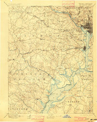
~ Mt Vernon VA topo map, 1:125000 scale, 30 X 30 Minute, Historical, 1897, updated 1901
Mt Vernon, Virginia, USGS topographic map dated 1897.
Includes geographic coordinates (latitude and longitude). This topographic map is suitable for hiking, camping, and exploring, or framing it as a wall map.
Printed on-demand using high resolution imagery, on heavy weight and acid free paper, or alternatively on a variety of synthetic materials.
Topos available on paper, Waterproof, Poly, or Tyvek. Usually shipping rolled, unless combined with other folded maps in one order.
- Product Number: USGS-5304020
- Free digital map download (high-resolution, GeoPDF): Mt Vernon, Virginia (file size: 7 MB)
- Map Size: please refer to the dimensions of the GeoPDF map above
- Weight (paper map): ca. 55 grams
- Map Type: POD USGS Topographic Map
- Map Series: HTMC
- Map Verison: Historical
- Cell ID: 320671
- Scan ID: 189079
- Imprint Year: 1901
- Survey Year: 1888
- Datum: Unstated
- Map Projection: Unstated
- Map published by United States Geological Survey
- Map Language: English
- Scanner Resolution: 600 dpi
- Map Cell Name: Mount Vernon
- Grid size: 30 X 30 Minute
- Date on map: 1897
- Map Scale: 1:125000
- Geographical region: Virginia, United States
Neighboring Maps:
All neighboring USGS topo maps are available for sale online at a variety of scales.
Spatial coverage:
Topo map Mt Vernon, Virginia, covers the geographical area associated the following places:
- Country Roads - Cornwell - Lakewood Estates - Bryan Point - Westwood - West End - Fenwick - Carters - Jefferson Park - Westminster - Dunn Loring - Evermay - Livingston Grove - Huntington - Tysons Green - Thomason Park - Huntington - Springfield Station - Holmes Run Heights - Hillendale - Manassas Park - Avon Crest - Accotink - Berkshire - Saint Elmo - Armsleigh Park (historical) - Forest Hills - Crescent Hills - Locust Hill - American University Park - Greenwich Forest - Wilburdale - Vienna Woods - Fair Oaks - Barkers Crossroads - McLean Hamlet - Seven Corners - Annandale Acres - Hybla Valley - Hawthorne - Braddock - Evansdale - Fort Washington Estates - Newington - Potomac Heights - Colchester Acres - Sleepy Hollow Woods - Hampshire Knolls - Madison Manor - Old Belle Fair (historical) - Mount Hebron Park - Wakefield Forest - Buckingham - Windsor Estates - Addison Heights - Foxhall Crescent - Jefferson - Potomac Vista - Pleasant Ridge - Fairfax Woods - Brookdale - Crystal Spring Knolls - Springfield - Belmont Park - Broadwater Estates - Springvale - Arcturus - Belleair - Oak Ridge Estates - Rollingwood - Lamond Riggs - Arlington Heights - Lake Ridge - Springfield Square - Baileys Crossroads - Darbydale - Kenwood - Sun Valley - West Falls Church - Cathedral Heights - Occoquan Forest - Beechwood Hills - Belle Haven - East Arlington (historical) - Sumner - Orchard Bridge - Robie Manor - Beverley Hills - Hallmark Manor - Featherstone Shores - Brinetown (historical) - Country Club Hills - Winthrop (historical) - Lee Heights - Logan Circle - Fairview - Sunset Manor - McLean Gardens - Battery Park - Mohican Hills
- Map Area ID: AREA3938.5-77.5-77
- Northwest corner Lat/Long code: USGSNW39-77.5
- Northeast corner Lat/Long code: USGSNE39-77
- Southwest corner Lat/Long code: USGSSW38.5-77.5
- Southeast corner Lat/Long code: USGSSE38.5-77
- Northern map edge Latitude: 39
- Southern map edge Latitude: 38.5
- Western map edge Longitude: -77.5
- Eastern map edge Longitude: -77


