
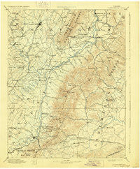
~ Harrisonburg VA topo map, 1:125000 scale, 30 X 30 Minute, Historical, 1892, updated 1928
Harrisonburg, Virginia, USGS topographic map dated 1892.
Includes geographic coordinates (latitude and longitude). This topographic map is suitable for hiking, camping, and exploring, or framing it as a wall map.
Printed on-demand using high resolution imagery, on heavy weight and acid free paper, or alternatively on a variety of synthetic materials.
Topos available on paper, Waterproof, Poly, or Tyvek. Usually shipping rolled, unless combined with other folded maps in one order.
- Product Number: USGS-5303926
- Free digital map download (high-resolution, GeoPDF): Harrisonburg, Virginia (file size: 7 MB)
- Map Size: please refer to the dimensions of the GeoPDF map above
- Weight (paper map): ca. 55 grams
- Map Type: POD USGS Topographic Map
- Map Series: HTMC
- Map Verison: Historical
- Cell ID: 65649
- Scan ID: 189005
- Imprint Year: 1928
- Survey Year: 1887
- Datum: Unstated
- Map Projection: Polyconic
- Map published by United States Geological Survey
- Map Language: English
- Scanner Resolution: 600 dpi
- Map Cell Name: Harrisonburg
- Grid size: 30 X 30 Minute
- Date on map: 1892
- Map Scale: 1:125000
- Geographical region: Virginia, United States
Neighboring Maps:
All neighboring USGS topo maps are available for sale online at a variety of scales.
Spatial coverage:
Topo map Harrisonburg, Virginia, covers the geographical area associated the following places:
- Fort Defiance - Emerald Hills - Hinton - Country View - Rocky Bar - Mayfield Trailer Court - Greenwood - Harrisonburg - Haneytown - Wyngate - Cedarmere - Shady Grove - Brookville Manor - Peacock Hill - Sandy Bottom - Paulington (historical) - Parkview - Barracks - Coakley Town - Newtown - Sneads Mobile Home Park - Verbena - East Point - Crossroads - Blue Ridge Acres - Williams Fork - Rushville - Bloomer Spring - Doylesville - Montevideo - Queen Charlotte - Shenandoah - Sampson - Flordon - Cedarmere (historical) - Nortonsville - Huntington Village - Pleasant Valley - Mountfair - Laurel Hills - Ivy Oaks - Blueridge Forest - Logan Village - Stadium Road Residence Area - Inglewood - Stillfield - Wilson Heights - Stonewall - Loch Leigh - Pirkey - Waynesboro - Crozet - Langford - Sherwood Manor - Piedmont - Lewis Hill East - Newtown - Ednam Village - Free Union - Montezuma - Timber Ridge - Fishersville - Keezletown - Freetown - Simmons Gap - Claymont Manor - Liberty Hill - Furnace - Fleeburg - Georgetown Green - Davis Shop - Country Green - Ednam - Comertown - Saint George - Knollwood - Stemphleytown - Yancey Mills - Melrose - Mill Ridge - McGaheysville - Meriwether Hill - White Hall - Dayton - Ashby Heights - Preston Heights - Colthurst - Inglecress - Red Mills - Buckingham Circle - Foothill Village - Island Ford - Owensville - Peach Grove (historical) - Grottoes - Lynnwood - West Leigh - Hopkins Spring - Orchard Acres - Belmont Estates
- Map Area ID: AREA38.538-79-78.5
- Northwest corner Lat/Long code: USGSNW38.5-79
- Northeast corner Lat/Long code: USGSNE38.5-78.5
- Southwest corner Lat/Long code: USGSSW38-79
- Southeast corner Lat/Long code: USGSSE38-78.5
- Northern map edge Latitude: 38.5
- Southern map edge Latitude: 38
- Western map edge Longitude: -79
- Eastern map edge Longitude: -78.5


