
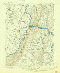
~ Harpers Ferry VA topo map, 1:125000 scale, 30 X 30 Minute, Historical, 1893, updated 1945
Harpers Ferry, Virginia, USGS topographic map dated 1893.
Includes geographic coordinates (latitude and longitude). This topographic map is suitable for hiking, camping, and exploring, or framing it as a wall map.
Printed on-demand using high resolution imagery, on heavy weight and acid free paper, or alternatively on a variety of synthetic materials.
Topos available on paper, Waterproof, Poly, or Tyvek. Usually shipping rolled, unless combined with other folded maps in one order.
- Product Number: USGS-5303916
- Free digital map download (high-resolution, GeoPDF): Harpers Ferry, Virginia (file size: 6 MB)
- Map Size: please refer to the dimensions of the GeoPDF map above
- Weight (paper map): ca. 55 grams
- Map Type: POD USGS Topographic Map
- Map Series: HTMC
- Map Verison: Historical
- Cell ID: 65645
- Scan ID: 188998
- Imprint Year: 1945
- Survey Year: 1884
- Datum: Unstated
- Map Projection: Polyconic
- Map published by United States Geological Survey
- Map Language: English
- Scanner Resolution: 600 dpi
- Map Cell Name: Harpers Ferry
- Grid size: 30 X 30 Minute
- Date on map: 1893
- Map Scale: 1:125000
- Geographical region: Virginia, United States
Neighboring Maps:
All neighboring USGS topo maps are available for sale online at a variety of scales.
Spatial coverage:
Topo map Harpers Ferry, Virginia, covers the geographical area associated the following places:
- Mountville - Morgan Grove - Round Hill - Winebrenners Crossroad - Fox Chase - Beamertown - Scattersville - Hollow Road Estates - Britain - Lucketts - Gleedsville - Picnic Woods Estates - Jefferson - Knoxville - Adamstown Village - Blue Ridge Estates - Saint Louis - Park Hall - Lamb Knolls - Wynkoop Mobile Home Park - Battletown - Castlemans Ferry - Paris - Howardsville - Fountain Dale - Wilson - Leesburg - Stockman Estates - Littletown - Bardane - Baker Heights - Brownsville - Fairview - Paeonian Springs - Harewood - Arch Bridge - Shepherdstown - Martinsburg - Mountville - Fairfield - Belvedere Heights - Brunswick - Clarks Gap - Der Spring Farms - Trego - Middleway - Trapp - Bolivar Heights - Waynes Way - Jefferson Village - Chestnut Grove - Morrisonville - Bidle Hill Acres - Foxfield Middletown - Rockcroft - Fisher Hill - Braddock Estates - Glenridge Estates - Silver Grove - Springdale - Boss Arnold Village - Brownsville - Pine Acres - Red Hill - Greensburg - Boydville - Broadlands - Minnick - Mechanicstown - Rice - Harmony (historical) - Meyerstown - Circleville - Homers Delight - Jefferson View - Briercrest Heights - Copperfield - Dunlin - Belmont - Swan Pond - Bellemonte - Harshman Estates - Point of Rocks Estates - EcoVillage of Loudoun County - Concord - Grubbs Corner - Crest Manor Estates - Catoctin Point - Franklintown - Valley Overlook - Berrys - Middletown Manor - Park Hall Estates - Hawbottom Heights - Moser - Middlebrook - Springview - Braddock Heights - Potomac Vistas - Van Clevesville
- Map Area ID: AREA39.539-78-77.5
- Northwest corner Lat/Long code: USGSNW39.5-78
- Northeast corner Lat/Long code: USGSNE39.5-77.5
- Southwest corner Lat/Long code: USGSSW39-78
- Southeast corner Lat/Long code: USGSSE39-77.5
- Northern map edge Latitude: 39.5
- Southern map edge Latitude: 39
- Western map edge Longitude: -78
- Eastern map edge Longitude: -77.5


