
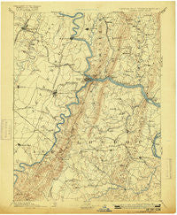
~ Harpers Ferry VA topo map, 1:125000 scale, 30 X 30 Minute, Historical, 1893, updated 1916
Harpers Ferry, Virginia, USGS topographic map dated 1893.
Includes geographic coordinates (latitude and longitude). This topographic map is suitable for hiking, camping, and exploring, or framing it as a wall map.
Printed on-demand using high resolution imagery, on heavy weight and acid free paper, or alternatively on a variety of synthetic materials.
Topos available on paper, Waterproof, Poly, or Tyvek. Usually shipping rolled, unless combined with other folded maps in one order.
- Product Number: USGS-5303912
- Free digital map download (high-resolution, GeoPDF): Harpers Ferry, Virginia (file size: 6 MB)
- Map Size: please refer to the dimensions of the GeoPDF map above
- Weight (paper map): ca. 55 grams
- Map Type: POD USGS Topographic Map
- Map Series: HTMC
- Map Verison: Historical
- Cell ID: 65645
- Scan ID: 188992
- Imprint Year: 1916
- Survey Year: 1884
- Datum: Unstated
- Map Projection: Unstated
- Map published by United States Geological Survey
- Map Language: English
- Scanner Resolution: 600 dpi
- Map Cell Name: Harpers Ferry
- Grid size: 30 X 30 Minute
- Date on map: 1893
- Map Scale: 1:125000
- Geographical region: Virginia, United States
Neighboring Maps:
All neighboring USGS topo maps are available for sale online at a variety of scales.
Spatial coverage:
Topo map Harpers Ferry, Virginia, covers the geographical area associated the following places:
- Potomac Crest - Wynkoop Spring - Copperfield - Trapp Hill - Harmony (historical) - Back Swamp - Middletown View - Hillsboro - West Middletown Estates - Meyerstown - Halltown - Jefferson View - Snyders Landing - Belmont Greene - Wynkoop Mobile Home Park - Top Hill - Broad Run - Mount Pleasant - River Park - Fisher Hill - Calmes Neck Estates - Mountain Lake - Frogtown - Valley Overlook - Arch Bridge - Mountville - Care Free Acres - Sunny Ridge - Boydville - Waynes Way - Knoxville - Mount Pleasant - Berrys - Bolington - Washington Junction - Battletown - Station Roads - Garretts Mill - Webbtown - Moler Crossroads - Yarrowsburg - Cowell - Clarks Gap - Bloomfield - Unison - Mount Briar - Shoemaker - Holter - Lockwood Heights - North Fork - Morningside - Potomac Overlook - Arnoldtown - Blair - Stockman Estates - Crown Estates - Harvest Acres - Middletown South - Fox Chase - Millville - Virts Corner - Scattersville - Foltz (historical) - Jefferson Oaks - Egypt - Graves - Weverton - Castlemans Ferry - Skyline Estates - Pleasant Valley - Virginius (historical) - Briercrest Heights - Blue Ridge Estates - Brownsville - Riverside - Winebrenners Crossroad - Bradbury Heights - Shepherdstown - Appletown - Round Hill - Catoctin Point - Sunrise - Wilber Woods - Shrys Store - Coblentz Heights - Potomac Vistas - Loudoun Heights - Sunset View - Lamb Knolls - Longwood - Rock Hall - Middleway - Hawbottom - Skeetersville - Samples Manor - Woodcrest - Kelview - Georges Mill - Heatherfield - Trapp
- Map Area ID: AREA39.539-78-77.5
- Northwest corner Lat/Long code: USGSNW39.5-78
- Northeast corner Lat/Long code: USGSNE39.5-77.5
- Southwest corner Lat/Long code: USGSSW39-78
- Southeast corner Lat/Long code: USGSSE39-77.5
- Northern map edge Latitude: 39.5
- Southern map edge Latitude: 39
- Western map edge Longitude: -78
- Eastern map edge Longitude: -77.5


