
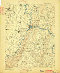
~ Harpers Ferry VA topo map, 1:125000 scale, 30 X 30 Minute, Historical, 1893, updated 1902
Harpers Ferry, Virginia, USGS topographic map dated 1893.
Includes geographic coordinates (latitude and longitude). This topographic map is suitable for hiking, camping, and exploring, or framing it as a wall map.
Printed on-demand using high resolution imagery, on heavy weight and acid free paper, or alternatively on a variety of synthetic materials.
Topos available on paper, Waterproof, Poly, or Tyvek. Usually shipping rolled, unless combined with other folded maps in one order.
- Product Number: USGS-5303906
- Free digital map download (high-resolution, GeoPDF): Harpers Ferry, Virginia (file size: 7 MB)
- Map Size: please refer to the dimensions of the GeoPDF map above
- Weight (paper map): ca. 55 grams
- Map Type: POD USGS Topographic Map
- Map Series: HTMC
- Map Verison: Historical
- Cell ID: 65645
- Scan ID: 188989
- Imprint Year: 1902
- Survey Year: 1884
- Datum: Unstated
- Map Projection: Unstated
- Map published by United States Geological Survey
- Map Language: English
- Scanner Resolution: 600 dpi
- Map Cell Name: Harpers Ferry
- Grid size: 30 X 30 Minute
- Date on map: 1893
- Map Scale: 1:125000
- Geographical region: Virginia, United States
Neighboring Maps:
All neighboring USGS topo maps are available for sale online at a variety of scales.
Spatial coverage:
Topo map Harpers Ferry, Virginia, covers the geographical area associated the following places:
- Woodburn - Hawbottom Heights - Taylors Landing - Brunswick - Lucketts - Lovettsville - Moler Crossroads - Valley Heights - Potomac Vistas - Holter - Apple Glen - Stringtown - Mountville - Johnsontown - Middlebrook - Springdale - Oatlands - Georges Mill - Heatherfield - Stockman Estates - Keister - Greggsville - Mount Briar - Shepherdstown - Martinsburg - Kabletown - Zittlestown - Rice - Knoxville - Jefferson View - Sycolin - Crown Estates - Horman - Stumptown - Middleway - Virts Corner - Park Hall Estates - Braddock Estates - Reedson - Strawleigh - Summit Point - Irish Hill - Lincoln - Mountville - Britain - Middletown Manor - Fisher Hill - Gambrill South - Adam Stephen Homes - Willow Lake - Lander - Purcellville - Virginius (historical) - Der Spring Farms - Powells Grove - Broad Run - Boydville - Jefferson Court - Morgan Grove - Corner House - Berkeley Place - Douglas Grove - Bidle Hill Acres - Gaylord - Jefferson - Longview - Clevelandville - Red Hill - Bells Mill - Fox Chase - Webbtown - Potomac Valley Farms - Frostown - Gleedsville - Grubbs Corner - Flint Hill - Station Roads - Riverside - Boss Arnold Village - Mountain Mission - Homers Delight - Taylorstown - West Middletown Estates - Airmont - Broadlands - Meyerstown - EcoVillage of Loudoun County - Pleasant Valley - Somerset - Marble Quarry - Middletown Valley Estates - Valley View - Pine Acres - Coblentz Heights - Rippon - Belvedere Heights - Unison - Point of Rocks - Rosemont - Paxson
- Map Area ID: AREA39.539-78-77.5
- Northwest corner Lat/Long code: USGSNW39.5-78
- Northeast corner Lat/Long code: USGSNE39.5-77.5
- Southwest corner Lat/Long code: USGSSW39-78
- Southeast corner Lat/Long code: USGSSE39-77.5
- Northern map edge Latitude: 39.5
- Southern map edge Latitude: 39
- Western map edge Longitude: -78
- Eastern map edge Longitude: -77.5


