
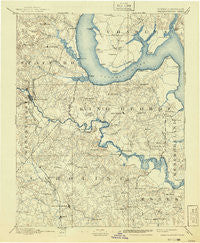
~ Fredericksburg VA topo map, 1:125000 scale, 30 X 30 Minute, Historical, 1894, updated 1941
Fredericksburg, Virginia, USGS topographic map dated 1894.
Includes geographic coordinates (latitude and longitude). This topographic map is suitable for hiking, camping, and exploring, or framing it as a wall map.
Printed on-demand using high resolution imagery, on heavy weight and acid free paper, or alternatively on a variety of synthetic materials.
Topos available on paper, Waterproof, Poly, or Tyvek. Usually shipping rolled, unless combined with other folded maps in one order.
- Product Number: USGS-5303866
- Free digital map download (high-resolution, GeoPDF): Fredericksburg, Virginia (file size: 7 MB)
- Map Size: please refer to the dimensions of the GeoPDF map above
- Weight (paper map): ca. 55 grams
- Map Type: POD USGS Topographic Map
- Map Series: HTMC
- Map Verison: Historical
- Cell ID: 65520
- Scan ID: 188953
- Imprint Year: 1941
- Survey Year: 1888
- Datum: Unstated
- Map Projection: Polyconic
- Map published by United States Geological Survey
- Map Language: English
- Scanner Resolution: 600 dpi
- Map Cell Name: Fredericksburg
- Grid size: 30 X 30 Minute
- Date on map: 1894
- Map Scale: 1:125000
- Geographical region: Virginia, United States
Neighboring Maps:
All neighboring USGS topo maps are available for sale online at a variety of scales.
Spatial coverage:
Topo map Fredericksburg, Virginia, covers the geographical area associated the following places:
- Heritage Oaks - Hooes - Debruyn - Skywoods - Falmouth Bridge - Woodford - Hard Corner - Jefferson Place - Phillips - Aquia Overlook - Monroe Corner - Potomac Hills - Willamsburg on the Potomac - Jacksontown (historical) - Raspberry - Stonebridge at Widewater - North Potomac - Perry Farms - Argyle Terrace - Greenstreet Mobile Home Park - Cresent Pointe - Crows Nest Harbor - Beverly Forest - Northern View Estates - Settlers Landing - Chatham Farms - Leeland Heights - Peppermint Forest - Cranewood - Etta - Clearview Heights - Moores Corner - Falmouth Heights - Sunnyside - Courts at Stafford - Marshall Estates - Georgetown East - Mayfield - High School Heights - Dartmoor - J A Macgregor Estate - Hamlin Hills - Cranes Corner - Knotsmythes Landing - Cash Corner - Stafford Greens - Lansberry Park - Riverside - Aquia Inlet Estates - Fairview and Oakland - Somerset Beach - Northridge - Weedons Fork - Presidential Lakes - Acors Corner - Victoria Woods - Little Creek - Smith Lake Estates - Ferry Road - Howards Corner - Haymount - Brookewood Farms - Lloyds - Hickory Hill - Stowe of Amyclae - Autumn Ridge - Mount Ringold Farm - Rivendell - Coal Landing - Rappahannock Corner - Whites (historical) - Bel Air - Taylors - Graninger - Biscoe - Shiloh - Chatam - Marlboro - Rolling Meadows - Melody Acres - Passapatanzy - Bourne - Fines Corner - Thorny Point Farm - The Oaks Mobile Home Park - Rappahannock Academy - Hampstead - Stafford - Butterfield - Pomona - Gordon and Keziah Sullivan Estates - Youngstead - Whitson Run - Huntington Hills - Deacon Woods - Broaddus - Jacks Fork - Clarion Woods - Kendallwood East - Cannon Ridge
- Map Area ID: AREA38.538-77.5-77
- Northwest corner Lat/Long code: USGSNW38.5-77.5
- Northeast corner Lat/Long code: USGSNE38.5-77
- Southwest corner Lat/Long code: USGSSW38-77.5
- Southeast corner Lat/Long code: USGSSE38-77
- Northern map edge Latitude: 38.5
- Southern map edge Latitude: 38
- Western map edge Longitude: -77.5
- Eastern map edge Longitude: -77


