
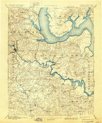
~ Fredericksburg VA topo map, 1:125000 scale, 30 X 30 Minute, Historical, 1894, updated 1930
Fredericksburg, Virginia, USGS topographic map dated 1894.
Includes geographic coordinates (latitude and longitude). This topographic map is suitable for hiking, camping, and exploring, or framing it as a wall map.
Printed on-demand using high resolution imagery, on heavy weight and acid free paper, or alternatively on a variety of synthetic materials.
Topos available on paper, Waterproof, Poly, or Tyvek. Usually shipping rolled, unless combined with other folded maps in one order.
- Product Number: USGS-5303864
- Free digital map download (high-resolution, GeoPDF): Fredericksburg, Virginia (file size: 7 MB)
- Map Size: please refer to the dimensions of the GeoPDF map above
- Weight (paper map): ca. 55 grams
- Map Type: POD USGS Topographic Map
- Map Series: HTMC
- Map Verison: Historical
- Cell ID: 65520
- Scan ID: 188951
- Imprint Year: 1930
- Survey Year: 1888
- Datum: Unstated
- Map Projection: Polyconic
- Map published by United States Geological Survey
- Map Language: English
- Scanner Resolution: 600 dpi
- Map Cell Name: Fredericksburg
- Grid size: 30 X 30 Minute
- Date on map: 1894
- Map Scale: 1:125000
- Geographical region: Virginia, United States
Neighboring Maps:
All neighboring USGS topo maps are available for sale online at a variety of scales.
Spatial coverage:
Topo map Fredericksburg, Virginia, covers the geographical area associated the following places:
- Sealston - Monroe Corner - Woodleigh - Daltons - Waverly - Falmouth - Arkendale - Twin Oaks - Lake Ridge and Bethany Pointe - Weedons Fork - Fourmile Fork - Belvedere - Hallbrooke Woods - Weedonville - Potomac Creek Estates - Aquia Inlet Estates - Saint Georges Estates - Chatham Heights - Sunshine Acres - Hooes - Cedar Grove - Cobblestone - Cedar Bluff - Oakbrooke - Greenfield - Port Conway - Stratford Place - Heather Hills - Purkins Corner - Rappahannock Corner - Alden - Cash Corner - Misty Forest - Sams Ridge - J A Macgregor Estate - Lynwood - Locklears Landing - E O Brooks Subdivision - Argyle Hills - Osso - Rivendell - Leesville - Hickory Ridge - Sunnyside - Aqua Villa - Little Falls Village - Milford - Sunshine View - Somerset Beach - Harris - Braehead Woods - Collins Crossing - Serena Forest - Huntington Hills - Colonial Heights - Georgetown East - Portobago - Moss Neck - The Columns - Austin Ridge - Wallace Farms - Skinkers Corner - Stowe of Amyclae - Penn Manor - Hollymead - Brooke - Widewater - Leeland Station - Welcome Acres - Dickinsons Corner - Leeland Creek Estates - Clearview Heights - New Hope Estates - Grafton (historical) - Green Manor Estates - Eubank Corner - Falmouth Heights - Victoria Woods - Fairview and Oakland - Skywoods - Woods of Able Lake - White Oak Hills - Biscoe - Raintree - Raymonds Fork - Wrights Corner - Docstone Commons - Marshall Woods - Whites (historical) - Stonehill Estates - Light Oak Glen - Friendship Acres - Stafford Oaks - Maple Grove - Cherry Hill Estates - Willamsburg on the Potomac - Barrett Heights - Shawnee Forest - Bristol (historical) - Greenstreet Mobile Home Park
- Map Area ID: AREA38.538-77.5-77
- Northwest corner Lat/Long code: USGSNW38.5-77.5
- Northeast corner Lat/Long code: USGSNE38.5-77
- Southwest corner Lat/Long code: USGSSW38-77.5
- Southeast corner Lat/Long code: USGSSE38-77
- Northern map edge Latitude: 38.5
- Southern map edge Latitude: 38
- Western map edge Longitude: -77.5
- Eastern map edge Longitude: -77


