
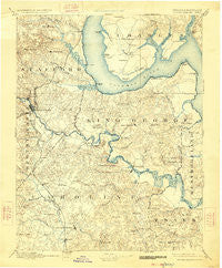
~ Fredericksburg VA topo map, 1:125000 scale, 30 X 30 Minute, Historical, 1894, updated 1926
Fredericksburg, Virginia, USGS topographic map dated 1894.
Includes geographic coordinates (latitude and longitude). This topographic map is suitable for hiking, camping, and exploring, or framing it as a wall map.
Printed on-demand using high resolution imagery, on heavy weight and acid free paper, or alternatively on a variety of synthetic materials.
Topos available on paper, Waterproof, Poly, or Tyvek. Usually shipping rolled, unless combined with other folded maps in one order.
- Product Number: USGS-5303862
- Free digital map download (high-resolution, GeoPDF): Fredericksburg, Virginia (file size: 7 MB)
- Map Size: please refer to the dimensions of the GeoPDF map above
- Weight (paper map): ca. 55 grams
- Map Type: POD USGS Topographic Map
- Map Series: HTMC
- Map Verison: Historical
- Cell ID: 65520
- Scan ID: 188949
- Imprint Year: 1926
- Survey Year: 1888
- Datum: NAD
- Map Projection: Polyconic
- Map published by United States Geological Survey
- Map Language: English
- Scanner Resolution: 600 dpi
- Map Cell Name: Fredericksburg
- Grid size: 30 X 30 Minute
- Date on map: 1894
- Map Scale: 1:125000
- Geographical region: Virginia, United States
Neighboring Maps:
All neighboring USGS topo maps are available for sale online at a variety of scales.
Spatial coverage:
Topo map Fredericksburg, Virginia, covers the geographical area associated the following places:
- Charlestown Commons - Leeland Creek Estates - Martins Corner - Villboro - Massaponax - Hard Corner - Arbor Glen - Moreland - Beau Ridge - Bristol (historical) - Deacon Road Estates - Brooksmill Estates - Hillcrest Terrace - Knotsmythes Landing - O Bannon Land - Part Little Falls - Santee (historical) - Fines Corner - Quarry Estates - Country Ridge - Jacks Fork - Cedar Bluff - Freds Corner - Hampstead Village - Potomac Shores - The Columns - Mica - Brooke - Johnsons Corner - Bexley Manor - Passapatanzy - Subdivision Estates - Milbank - Sweetbriar Woods - High School Heights - Aquia Beach - Port Royal - Bridle Lake Estates - Howards Corner - Sylvania Heights - Rivendell - Aquia Creek - Graninger Mobile Home Park - Argyle Heights - Somerset Beach - White Oak Hills - Poplar Hills - Whitaker - Haymount - Fritters Corner - Sycamore Ridge - Stefin Woods Estate - Penny Corner - Dittmeier - Potomac Knolls - Portobago - Cherryfield (historical) - Chatham Village - Friendship Acres - Cabin Creekwood - Rixey - Somerset Landing - Olney Corner - Marshope - Clearview - Graves Corner - Wellford Sullivan Estate - Willamsburg on the Potomac - Ironsides - The Holly Woods - Glenwood Forest - Townes of Ashleigh - Dogue - Mattox Bridge - Northridge - Chatham Heights - Heritage Commons - Estates of Widewater Pond - Mayfield - E O Brooks Subdivision - Lyons Den - Claiborne - Gayles - Carruthers Corner - Gordon and Keziah Sullivan Estates - Whitson Ridge - Chance - Falmouth Heights - Guinea - Freedom Estates - Moss Neck - Elizabeth Park - Maryton - Staffordborough - Hickory Ridge - Chatham Farms - Confederate Ridge - Brooks - River Heights - Hill Top
- Map Area ID: AREA38.538-77.5-77
- Northwest corner Lat/Long code: USGSNW38.5-77.5
- Northeast corner Lat/Long code: USGSNE38.5-77
- Southwest corner Lat/Long code: USGSSW38-77.5
- Southeast corner Lat/Long code: USGSSE38-77
- Northern map edge Latitude: 38.5
- Southern map edge Latitude: 38
- Western map edge Longitude: -77.5
- Eastern map edge Longitude: -77


