
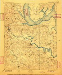
~ Fredericksburg VA topo map, 1:125000 scale, 30 X 30 Minute, Historical, 1894, updated 1910
Fredericksburg, Virginia, USGS topographic map dated 1894.
Includes geographic coordinates (latitude and longitude). This topographic map is suitable for hiking, camping, and exploring, or framing it as a wall map.
Printed on-demand using high resolution imagery, on heavy weight and acid free paper, or alternatively on a variety of synthetic materials.
Topos available on paper, Waterproof, Poly, or Tyvek. Usually shipping rolled, unless combined with other folded maps in one order.
- Product Number: USGS-5303856
- Free digital map download (high-resolution, GeoPDF): Fredericksburg, Virginia (file size: 7 MB)
- Map Size: please refer to the dimensions of the GeoPDF map above
- Weight (paper map): ca. 55 grams
- Map Type: POD USGS Topographic Map
- Map Series: HTMC
- Map Verison: Historical
- Cell ID: 65520
- Scan ID: 188946
- Imprint Year: 1910
- Survey Year: 1888
- Datum: Unstated
- Map Projection: Unstated
- Map published by United States Geological Survey
- Map Language: English
- Scanner Resolution: 600 dpi
- Map Cell Name: Fredericksburg
- Grid size: 30 X 30 Minute
- Date on map: 1894
- Map Scale: 1:125000
- Geographical region: Virginia, United States
Neighboring Maps:
All neighboring USGS topo maps are available for sale online at a variety of scales.
Spatial coverage:
Topo map Fredericksburg, Virginia, covers the geographical area associated the following places:
- Dahlgren Junction (historical) - Jacks Fork - Courthouse Square at Stafford - Foreston Woods North - Garrisonville Estates - Michaelbrooke Estates - Port Royal - Berthaville - Milford - Little Falls Village - E O Brooks Subdivision - Mount Air - River Heights - Montague - Estates of Brooke - Villboro - Courts at Stafford - Fairview and Oakland - Basil Gordon - Lee's Hill Mobile Home Park - Stuart Corner - Vintage Oaks - Hicks Mill - Serena Forest - Bridle Lake Estates - Woodlawn - Locks Corner - Liberty Place - The Oaks Mobile Home Park - Wrightsville - Maryes Heights - Cedar Bluff - Bristol (historical) - Dogue - Fredericksburg - Claiborne - Crows Nest Harbor - Port Conway - Whitson Ridge - Stefin Woods Estate - Phillips - Canterbury Estates - Arnolds Corner - Fines Corner - Long Branch - Bethlehem Fork - Bourne - Brooks - Bowers - Huntington Hills - Compton - Hazel Hill - Massaponax - Northern View Estates - Presidential Lakes - Hazelwood - Corbin - Ramoth Church Estates - Cranewood - Maryton - Belle Oaks - Mount Pleasant Estates - Raymonds Fork - Lynwood - Boscobel Woods - Grace Shelton Family Subdivision - Baylortown - Flippos Corner - Blythedale - Lake Ridge and Bethany Pointe - Chatam - Argyle Terrace - Sunnyside Division - Woodford - Chatham Farms - Vestavia Woods - Brookfield - Walter Roberson Estate - Vista Woods - Bellvue - Heritage Oaks - Biscoe - Grafton (historical) - Will-More - Locklears Knoll - Greenstreet Mobile Home Park - Stafford - Cabin Creekwood - Olney Corner - Smith Lake Landing - Penn Manor - Grandview - Young Corner - King George - Beverly Forest - Belmont Hills - Falmouth Heights - Ninde - Shenandoah - Freedom Estates
- Map Area ID: AREA38.538-77.5-77
- Northwest corner Lat/Long code: USGSNW38.5-77.5
- Northeast corner Lat/Long code: USGSNE38.5-77
- Southwest corner Lat/Long code: USGSSW38-77.5
- Southeast corner Lat/Long code: USGSSE38-77
- Northern map edge Latitude: 38.5
- Southern map edge Latitude: 38
- Western map edge Longitude: -77.5
- Eastern map edge Longitude: -77


