
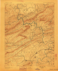
~ Dublin VA topo map, 1:125000 scale, 30 X 30 Minute, Historical, 1891, updated 1899
Dublin, Virginia, USGS topographic map dated 1891.
Includes geographic coordinates (latitude and longitude). This topographic map is suitable for hiking, camping, and exploring, or framing it as a wall map.
Printed on-demand using high resolution imagery, on heavy weight and acid free paper, or alternatively on a variety of synthetic materials.
Topos available on paper, Waterproof, Poly, or Tyvek. Usually shipping rolled, unless combined with other folded maps in one order.
- Product Number: USGS-5303812
- Free digital map download (high-resolution, GeoPDF): Dublin, Virginia (file size: 9 MB)
- Map Size: please refer to the dimensions of the GeoPDF map above
- Weight (paper map): ca. 55 grams
- Map Type: POD USGS Topographic Map
- Map Series: HTMC
- Map Verison: Historical
- Cell ID: 65376
- Scan ID: 188910
- Imprint Year: 1899
- Survey Year: 1887
- Datum: Unstated
- Map Projection: Unstated
- Map published by United States Geological Survey
- Map Language: English
- Scanner Resolution: 600 dpi
- Map Cell Name: Dublin
- Grid size: 30 X 30 Minute
- Date on map: 1891
- Map Scale: 1:125000
- Geographical region: Virginia, United States
Neighboring Maps:
All neighboring USGS topo maps are available for sale online at a variety of scales.
Spatial coverage:
Topo map Dublin, Virginia, covers the geographical area associated the following places:
- Dry Branch - Norcross - Plum Creek - Alum Springs - Wabash (historical) - Ballard - Snowville - White Pine Lodge - New River - Willowton - Simpkins Village - Pulaski - Hatcher - Thessalia - Goldbond - North Pearisburg - Walton - Narrows - Cowan - New Town - Mountain Lake - Burlington Mills - Penvir - Belspring - Bella Vista - Crandon - Gray Sulphur Springs (historical) - Mountain View - Gallimore - Kimballton - Ridgefield - Radford - Lovern - Cloverdale - Rock Camp - Chestnut Knob - Cashers Hill - Highland Hills - Simpkinstown - Wurno - Eggleston - Hill Top - Grandview Heights - Fairlawn - First Ford - Whitethorne - Neponset - Little Creek - Springdale - Childress - Dublin - Pepper - Highland Park - Poplar Hill - Mercers Saltworks (historical) - Lerona - Staytide (historical) - Haven Heights - Trigg - Bozoo - McCoy - Newbern - Bear Spring - Cashmere - Shumate - Clark (historical) - Maybrook - Weldon - Hickory Hills - Wenonah (historical) - Belle Heth - Centerville - Parrott - Hilton Village - Elgood - Pembroke - Smithfield - Monroe Terrace - Lurich - Stange Mines (historical) - Klotz - Assurance - Cedar Valley - Mill Village - Midway - French - Forest Park - Peterstown - Mount Olivet - Radford Village - Wake Forest - Mechanicsburg - Churchwood (historical) - Mandeville - College Park - Highland - Lick Creek - Altoona Mines (historical) - McAdam - Goodwins Ferry (historical)
- Map Area ID: AREA37.537-81-80.5
- Northwest corner Lat/Long code: USGSNW37.5-81
- Northeast corner Lat/Long code: USGSNE37.5-80.5
- Southwest corner Lat/Long code: USGSSW37-81
- Southeast corner Lat/Long code: USGSSE37-80.5
- Northern map edge Latitude: 37.5
- Southern map edge Latitude: 37
- Western map edge Longitude: -81
- Eastern map edge Longitude: -80.5


