
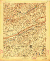
~ Bristol VA topo map, 1:125000 scale, 30 X 30 Minute, Historical, 1902, updated 1923
Bristol, Virginia, USGS topographic map dated 1902.
Includes geographic coordinates (latitude and longitude). This topographic map is suitable for hiking, camping, and exploring, or framing it as a wall map.
Printed on-demand using high resolution imagery, on heavy weight and acid free paper, or alternatively on a variety of synthetic materials.
Topos available on paper, Waterproof, Poly, or Tyvek. Usually shipping rolled, unless combined with other folded maps in one order.
- Product Number: USGS-5303764
- Free digital map download (high-resolution, GeoPDF): Bristol, Virginia (file size: 9 MB)
- Map Size: please refer to the dimensions of the GeoPDF map above
- Weight (paper map): ca. 55 grams
- Map Type: POD USGS Topographic Map
- Map Series: HTMC
- Map Verison: Historical
- Cell ID: 65058
- Scan ID: 188869
- Imprint Year: 1923
- Survey Year: 1895
- Datum: Unstated
- Map Projection: Unstated
- Map published by United States Geological Survey
- Map Language: English
- Scanner Resolution: 600 dpi
- Map Cell Name: Bristol
- Grid size: 30 X 30 Minute
- Date on map: 1902
- Map Scale: 1:125000
- Geographical region: Virginia, United States
Neighboring Maps:
All neighboring USGS topo maps are available for sale online at a variety of scales.
Spatial coverage:
Topo map Bristol, Virginia, covers the geographical area associated the following places:
- Point Truth - Barytes - Fleenora Park (historical) - High Meadows - Fleenors - Booker - Artrip - Painter Spring - Larwood - Fishdam (historical) - Fulkerson - Tennessee Hills - Edgemont - Cranes Nest - Vane (historical) - Masons Store (historical) - Graystone Estates - Hemlock - Oakview - Marlyn Hills - Fair Acres - Oak Grove - Owen Corner - Phillip - Banner - Weaver - Flatwoods - Springdale - Maytown - Vicco - Fairmount - Lone Star - Lime Hill - Wyndale - Candler - Corner - Brairwood Acres - Mount Tucker Addition - Driftwood - Crackers Neck - Indian Hills - Thomas Heights - Hill Country - Saint Paul - Bristol - Barnett - Evergreen Hills - Sunrise Valley - Orebank - Nash Ford - Briarwood - Rock City - Dorado - Dorton Fort - Maces Spring - Hunter Hills - Pullontown - Holston View - Mew - Grigbys Store - Avoca - Cummings Heights - Mount Area Estates - Cross - Shakesville - Dickensonville - Friendship - Craigs Mill - Westfield - Withers - Big Creek (historical) - Ridgefield - Grassy Creek - Parkwood Estates - Twin Springs - Carterton - Carbo - Cedar Valley - Walnut Grove - Buncombe - Rocktown - Vance - Dry Fork - Sunny Brook - Clinchfield - Cleveland - Rush Corner - Trammel (historical) - Parsonage - Bickley Mill - Colonial Heights - Willis - Sunny Hills - Briardale - Virginia City - Beechcliff Estates - Morefield - Jessees Mill - Maple Hill - Stony
- Map Area ID: AREA3736.5-82.5-82
- Northwest corner Lat/Long code: USGSNW37-82.5
- Northeast corner Lat/Long code: USGSNE37-82
- Southwest corner Lat/Long code: USGSSW36.5-82.5
- Southeast corner Lat/Long code: USGSSE36.5-82
- Northern map edge Latitude: 37
- Southern map edge Latitude: 36.5
- Western map edge Longitude: -82.5
- Eastern map edge Longitude: -82


