
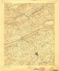
~ Bristol VA topo map, 1:125000 scale, 30 X 30 Minute, Historical, 1897
Bristol, Virginia, USGS topographic map dated 1897.
Includes geographic coordinates (latitude and longitude). This topographic map is suitable for hiking, camping, and exploring, or framing it as a wall map.
Printed on-demand using high resolution imagery, on heavy weight and acid free paper, or alternatively on a variety of synthetic materials.
Topos available on paper, Waterproof, Poly, or Tyvek. Usually shipping rolled, unless combined with other folded maps in one order.
- Product Number: USGS-5303756
- Free digital map download (high-resolution, GeoPDF): Bristol, Virginia (file size: 9 MB)
- Map Size: please refer to the dimensions of the GeoPDF map above
- Weight (paper map): ca. 55 grams
- Map Type: POD USGS Topographic Map
- Map Series: HTMC
- Map Verison: Historical
- Cell ID: 65058
- Scan ID: 188863
- Survey Year: 1895
- Datum: Unstated
- Map Projection: Unstated
- Map published by United States Geological Survey
- Map Language: English
- Scanner Resolution: 600 dpi
- Map Cell Name: Bristol
- Grid size: 30 X 30 Minute
- Date on map: 1897
- Map Scale: 1:125000
- Geographical region: Virginia, United States
Neighboring Maps:
All neighboring USGS topo maps are available for sale online at a variety of scales.
Spatial coverage:
Topo map Bristol, Virginia, covers the geographical area associated the following places:
- Kiser (historical) - Haskell - Lone Star - Banners Corner - Rust Hollow - West Ridge - Lawson (historical) - Oakview - Oakleigh Estates - Cedar Valley - Lime Hill - Walnut Grove - Hillcrest - Springdale - Vicco - Walnut Hill - Kingtown - Counts - Silica - Crab Orchard - Roebuck - Orebank - Leonardtown - Friendship - Temple Hill - Willow Springs - Dorado - Zenobia - Beechcliff Estates - Scenic Woods - West Dante - Fullers - Head of Linefork (historical) - Arcadia - Trammel (historical) - Bloomingdale - Virginia City - Belle Brook Estates - Dorton Fort - Holston - Avoca - Collingwood - Lake Park - Deerfield Acres - Shakesville - Fleenora Park (historical) - Blue Ridge - Rock Hill Park - Cleveland - Hemlock - Little Duck - Bristol - Haynesfield - Dungannon - Earheart (historical) - High Meadows - Bickley Mill - Paperville - Fair Acres - Lebanon - Grizzle (historical) - Burtons Ford - Mount Tucker Addition - Briardale - Kingsley Hills - Cold Spring - Rock City - Ridgedale - Virginia Hills - Oak Hill - Sac (historical) - Maple Hill - Hawkins Mill - Holston Valley - Redstone - Carbo - Candler - McConnell - Point Truth - Graystone Estates - Wallace - Walnut Grove - Brumley Gap - Carterton - Mystic Valley - Anderson - Belle Meadows - Vinegar Hill - Brookmead - Maytown - Bristol - Mew - Fugates Hill - Horizon Hills - Woodrow - Spring City - Fall Creek - Crackers Neck - Willis - Creswell
- Map Area ID: AREA3736.5-82.5-82
- Northwest corner Lat/Long code: USGSNW37-82.5
- Northeast corner Lat/Long code: USGSNE37-82
- Southwest corner Lat/Long code: USGSSW36.5-82.5
- Southeast corner Lat/Long code: USGSSE36.5-82
- Northern map edge Latitude: 37
- Southern map edge Latitude: 36.5
- Western map edge Longitude: -82.5
- Eastern map edge Longitude: -82


