
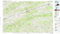
~ Wytheville VA topo map, 1:100000 scale, 30 X 60 Minute, Historical, 1982, updated 1988
Wytheville, Virginia, USGS topographic map dated 1982.
Includes geographic coordinates (latitude and longitude). This topographic map is suitable for hiking, camping, and exploring, or framing it as a wall map.
Printed on-demand using high resolution imagery, on heavy weight and acid free paper, or alternatively on a variety of synthetic materials.
Topos available on paper, Waterproof, Poly, or Tyvek. Usually shipping rolled, unless combined with other folded maps in one order.
- Product Number: USGS-5303714
- Free digital map download (high-resolution, GeoPDF): Wytheville, Virginia (file size: 25 MB)
- Map Size: please refer to the dimensions of the GeoPDF map above
- Weight (paper map): ca. 55 grams
- Map Type: POD USGS Topographic Map
- Map Series: HTMC
- Map Verison: Historical
- Cell ID: 68618
- Scan ID: 188820
- Imprint Year: 1988
- Woodland Tint: Yes
- Aerial Photo Year: 1975
- Edit Year: 1982
- Datum: NAD27
- Map Projection: Universal Transverse Mercator
- Map published by United States Geological Survey
- Map Language: English
- Scanner Resolution: 600 dpi
- Map Cell Name: Wytheville
- Grid size: 30 X 60 Minute
- Date on map: 1982
- Map Scale: 1:100000
- Geographical region: Virginia, United States
Neighboring Maps:
All neighboring USGS topo maps are available for sale online at a variety of scales.
Spatial coverage:
Topo map Wytheville, Virginia, covers the geographical area associated the following places:
- Hayters Gap - Saltville - Amelia - Sessex - Clarksville - Friendship - McConnell - Henrytown - Nebo - Groseclose Store - McMullin - Loves Mill - Scott Addition - Blessing - Vox - Giesley Mill - Kegleys - Shady Grove - Cripple Creek - Repass - Atkins - Attoway - Harr - Hubbard Junction - Groseclose Corner - Riverside - Stringtown - Riverside - Listening Rock - Crandull - Shingletown - New Haven - Nella - Grassy Creek - Ridgedale - Hooker - Stony Battery - Sugar Creek - Konnarock - Henderson - Cedar Branch - Seven Mile Ford - Fox - Blevins Crossroads - Midway - Bennington Mill - Vails Mill - Crowgeys - Favonia - Taylors Valley - Plum Creek - Ellendale - Tumbling Creek - Cold Spring - Neff - Emory - Sparta - Roberts Mill - Shiloh - Trout Dale - Snodgrass - Damascus - Osborns Store - Laurel Bloomery - Green Cove - Grubb - Marion - Jacob (historical) - Glenford - Independence - Groseclose - Ashleys - Parks Mill - Rockdell - Crumpler - Willard - Sturgills - Volney - Tuckerdale - Piney Creek - Rural Retreat - Silver Lake - Jacksons Store - Fallville - Blackwell - Belfast Mills - Abingdon - Lodi - Camp Tom Howard - Lower Elk Creek - Sulphur Springs Heights - Twin Oaks - Huddle - Murpheyville - Groseclose - Mouth of Wilson - Price Hill - McCready - Sugar Grove - Rosedale
- Map Area ID: AREA3736.5-82-81
- Northwest corner Lat/Long code: USGSNW37-82
- Northeast corner Lat/Long code: USGSNE37-81
- Southwest corner Lat/Long code: USGSSW36.5-82
- Southeast corner Lat/Long code: USGSSE36.5-81
- Northern map edge Latitude: 37
- Southern map edge Latitude: 36.5
- Western map edge Longitude: -82
- Eastern map edge Longitude: -81


