
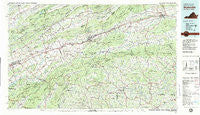
~ Wytheville VA topo map, 1:100000 scale, 30 X 60 Minute, Historical, 1982, updated 1983
Wytheville, Virginia, USGS topographic map dated 1982.
Includes geographic coordinates (latitude and longitude). This topographic map is suitable for hiking, camping, and exploring, or framing it as a wall map.
Printed on-demand using high resolution imagery, on heavy weight and acid free paper, or alternatively on a variety of synthetic materials.
Topos available on paper, Waterproof, Poly, or Tyvek. Usually shipping rolled, unless combined with other folded maps in one order.
- Product Number: USGS-5303712
- Free digital map download (high-resolution, GeoPDF): Wytheville, Virginia (file size: 25 MB)
- Map Size: please refer to the dimensions of the GeoPDF map above
- Weight (paper map): ca. 55 grams
- Map Type: POD USGS Topographic Map
- Map Series: HTMC
- Map Verison: Historical
- Cell ID: 68618
- Scan ID: 188819
- Imprint Year: 1983
- Woodland Tint: Yes
- Aerial Photo Year: 1975
- Edit Year: 1982
- Datum: NAD27
- Map Projection: Universal Transverse Mercator
- Map published by United States Geological Survey
- Map Language: English
- Scanner Resolution: 600 dpi
- Map Cell Name: Wytheville
- Grid size: 30 X 60 Minute
- Date on map: 1982
- Map Scale: 1:100000
- Geographical region: Virginia, United States
Neighboring Maps:
All neighboring USGS topo maps are available for sale online at a variety of scales.
Spatial coverage:
Topo map Wytheville, Virginia, covers the geographical area associated the following places:
- Blacklick - Azen - Grayson - Broadford - Quebec - Pleasant Heights - Abingdon - Mount Carmel - Green Spring - Spring Valley - Greenfield - Furnace Hill - Bridle Creek - Stratford - Fleet - Stony Battery - Offset - Mouth of Wilson - Vails Mill - Eureka - Peach Bottom - Clito Mill - Attoway - Cedar Bluff - Grubb - De Busk Mill - Shady Valley - Cripple Creek - Crandull - Saltville - Rural Retreat - Providence - Washington Springs - Flat Ridge - Morningside Hills - Stone Mill - Fuller - West Piney - Huddle - Cardwell Town - Glenford - Camp Tom Howard - Watauga - Speedwell - Shingletown - Snodgrass - Seven Mile Ford - Henrytown - Drowning Ford - Lowland - Vance Mill - Clinchburg - Allison Gap - Weavers Ford - Duncanville - Petunia - Chestnut Hill - Mount Zion - Piney Creek - Dry Fork - Favonia - New Haven - Sutherland - Loves Mill - Nebo - Mock Mill - Hubbard Junction - Turkey Fork - Ashleys - Kindrick - Sulphur Springs Heights - Groseclose Corner - Wytheville - Tumbling Creek - Plasterco - Eagle (historical) - Longhollow (historical) - Crockett - Belfast Mills - Winchester - Blackford - Konnarock - Plum Creek - Creek Junction - Neff - Osceola - Jacob (historical) - Rockdell - Bethel - Groseclose Store - Roberts Mill - Ketron Corner - Hayter - Lindell - Apple Grove - Keywood - Carsonville - Cedar Branch - Trout Dale - Simmerman
- Map Area ID: AREA3736.5-82-81
- Northwest corner Lat/Long code: USGSNW37-82
- Northeast corner Lat/Long code: USGSNE37-81
- Southwest corner Lat/Long code: USGSSW36.5-82
- Southeast corner Lat/Long code: USGSSE36.5-81
- Northern map edge Latitude: 37
- Southern map edge Latitude: 36.5
- Western map edge Longitude: -82
- Eastern map edge Longitude: -81


