
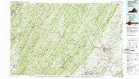
~ Winchester VA topo map, 1:100000 scale, 30 X 60 Minute, Historical, 1983, updated 1987
Winchester, Virginia, USGS topographic map dated 1983.
Includes geographic coordinates (latitude and longitude). This topographic map is suitable for hiking, camping, and exploring, or framing it as a wall map.
Printed on-demand using high resolution imagery, on heavy weight and acid free paper, or alternatively on a variety of synthetic materials.
Topos available on paper, Waterproof, Poly, or Tyvek. Usually shipping rolled, unless combined with other folded maps in one order.
- Product Number: USGS-5303708
- Free digital map download (high-resolution, GeoPDF): Winchester, Virginia (file size: 29 MB)
- Map Size: please refer to the dimensions of the GeoPDF map above
- Weight (paper map): ca. 55 grams
- Map Type: POD USGS Topographic Map
- Map Series: HTMC
- Map Verison: Historical
- Cell ID: 68601
- Scan ID: 188817
- Imprint Year: 1987
- Woodland Tint: Yes
- Visual Version Number: 2
- Aerial Photo Year: 1982
- Edit Year: 1983
- Datum: NAD27
- Map Projection: Universal Transverse Mercator
- Map published by United States Geological Survey
- Map Language: English
- Scanner Resolution: 600 dpi
- Map Cell Name: Winchester
- Grid size: 30 X 60 Minute
- Date on map: 1983
- Map Scale: 1:100000
- Geographical region: Virginia, United States
Neighboring Maps:
All neighboring USGS topo maps are available for sale online at a variety of scales.
Spatial coverage:
Topo map Winchester, Virginia, covers the geographical area associated the following places:
- North Mountain Estates - North River Mills - Reliance - Brookneil - Wellington Acres - Valley Acres - Lincoln Estates - Augusta - Good - Morton Grove - Wadesville - Bethel - Mosswood Hills - Cunningham - Northwood Hills - Mount Pleasant - Unger - Ridings Mill - Spring Gap (historical) - Milleson - Paxton Hills - Ridgeway - Union Corner - Siler - Wickham - Inwood - De Haven - Old Fields - Davis Ford - Cold Stream - Moorefield - High View Manor - Stephens City - Markwood - Clary - Hogue Creek Estates - Spring Meadows Trailer Park - McQuire - McNeill - Arcadia Mobile Home Park - Burnt Factory - Devland Estates - Chambersville - Freyco - Barnes Mill - Jericho (historical) - Raven Rocks - Briggs - Fairway Heights - Opequon - Claytonville - Shanghai - Darkesville - Cedar Creek Battlefield - Poplar Ridge - Blues Beach - Baughman Settlement - Bloomery - Cabaniss - Country Club Heights - Boyce - Shenandoah Hills - Donaldson - Reeses Mill - Waterloo Heights - Rosenberger - Grimes - Rest - Capon Springs - Bloom (historical) - Ridgeville - Millesons Mill - College Park - Burning Knolls - Needmore - Taylor - Largent - Oranda - Ruckman - Keyser - Round Hill - Tannery - White Hall - Greenway Estates - Sir John Addition - Ritters - Pyletown - Gordondale - Purgitsville - Parkins Mills - Klines Mill - Armel - Plainfield Heights - Glengary - Middletown - Woodchuck Heights - Burlington - Lebanon Church - Heritage Hills - Fort Run
- Map Area ID: AREA39.539-79-78
- Northwest corner Lat/Long code: USGSNW39.5-79
- Northeast corner Lat/Long code: USGSNE39.5-78
- Southwest corner Lat/Long code: USGSSW39-79
- Southeast corner Lat/Long code: USGSSE39-78
- Northern map edge Latitude: 39.5
- Southern map edge Latitude: 39
- Western map edge Longitude: -79
- Eastern map edge Longitude: -78


