
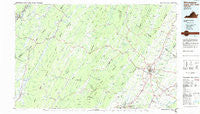
~ Winchester VA topo map, 1:100000 scale, 30 X 60 Minute, Historical, 1983, updated 1985
Winchester, Virginia, USGS topographic map dated 1983.
Includes geographic coordinates (latitude and longitude). This topographic map is suitable for hiking, camping, and exploring, or framing it as a wall map.
Printed on-demand using high resolution imagery, on heavy weight and acid free paper, or alternatively on a variety of synthetic materials.
Topos available on paper, Waterproof, Poly, or Tyvek. Usually shipping rolled, unless combined with other folded maps in one order.
- Product Number: USGS-5303706
- Free digital map download (high-resolution, GeoPDF): Winchester, Virginia (file size: 16 MB)
- Map Size: please refer to the dimensions of the GeoPDF map above
- Weight (paper map): ca. 55 grams
- Map Type: POD USGS Topographic Map
- Map Series: HTMC
- Map Verison: Historical
- Cell ID: 68601
- Scan ID: 188816
- Imprint Year: 1985
- Woodland Tint: Yes
- Aerial Photo Year: 1982
- Edit Year: 1983
- Datum: NAD27
- Map Projection: Universal Transverse Mercator
- Planimetric: Yes
- Map published by United States Geological Survey
- Map Language: English
- Scanner Resolution: 600 dpi
- Map Cell Name: Winchester
- Grid size: 30 X 60 Minute
- Date on map: 1983
- Map Scale: 1:100000
- Geographical region: Virginia, United States
Neighboring Maps:
All neighboring USGS topo maps are available for sale online at a variety of scales.
Spatial coverage:
Topo map Winchester, Virginia, covers the geographical area associated the following places:
- Layside Estates - Nero (historical) - Bubbling Spring - Hooks Mills - Arcadia Mobile Home Park - Miller Heights - Johnson - Cold Stream - De Haven - Northwood Hills - Largent - Moorefield - Dawson - Ritters - Indian Hollow - Blues Beach - McNeill - Wheatfield - Gerrardstown - Wadesville - Whitacre - Bloomery - Junction - Yellow Spring - North River Mills - Jericho (historical) - Green Spring - Mechanicsburg - Country Park - Albin - Valley (historical) - Gordondale - Stephens City - Goose Nest - Slanesville - Delray - Brucetown - Dillons Run (historical) - Canterburg - Fairway Estates - Nollville - Wellington Acres - Clear Brook - Sedan - Old Fields - Rock Enon - Black Oak - Middletown - Apple View Estates - Darkesville - Swimley - Donaldson - Kernstown - Neals Run - Saratoga - Poplar Ridge - Rest - Lincoln Estates - Grimes - De Haveland Estates - Waterloo Heights - Rolling Fields - Boyce - Romney - Briggs - Tulip - Leetown - Heritage Hills - Forge Hill - Chestnut Grove Estates - Rosenberger - Bartonsville - North Mountain Estates - Capon Lake - Meadow - Winchester - Jackson Woods - Siler - Gravel Springs - Ole Orchard Estates - Noswad (historical) - North Frederick Terrace - Shenandoah Mobile Home Park - Baughman Settlement - Tannery - Blue Ridge Downs - Zepp - Freyco - Raven Rocks - Westwood - Stonebrook Farms - Lost Corner - Mosswood Hills - Milldale - Peach Orchard Inn Farms - Keeneland - Cedar Hill - Lakewood Acres - Nieswanders Fort - Lake Frederick
- Map Area ID: AREA39.539-79-78
- Northwest corner Lat/Long code: USGSNW39.5-79
- Northeast corner Lat/Long code: USGSNE39.5-78
- Southwest corner Lat/Long code: USGSSW39-79
- Southeast corner Lat/Long code: USGSSE39-78
- Northern map edge Latitude: 39.5
- Southern map edge Latitude: 39
- Western map edge Longitude: -79
- Eastern map edge Longitude: -78


