
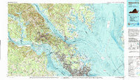
~ Williamsburg VA topo map, 1:100000 scale, 30 X 60 Minute, Historical, 1984, updated 1990
Williamsburg, Virginia, USGS topographic map dated 1984.
Includes geographic coordinates (latitude and longitude). This topographic map is suitable for hiking, camping, and exploring, or framing it as a wall map.
Printed on-demand using high resolution imagery, on heavy weight and acid free paper, or alternatively on a variety of synthetic materials.
Topos available on paper, Waterproof, Poly, or Tyvek. Usually shipping rolled, unless combined with other folded maps in one order.
- Product Number: USGS-5303702
- Free digital map download (high-resolution, GeoPDF): Williamsburg, Virginia (file size: 29 MB)
- Map Size: please refer to the dimensions of the GeoPDF map above
- Weight (paper map): ca. 55 grams
- Map Type: POD USGS Topographic Map
- Map Series: HTMC
- Map Verison: Historical
- Cell ID: 68591
- Scan ID: 188814
- Imprint Year: 1990
- Woodland Tint: Yes
- Visual Version Number: 1
- Aerial Photo Year: 1982
- Edit Year: 1984
- Datum: NAD27
- Map Projection: Universal Transverse Mercator
- Map published by United States Geological Survey
- Map Language: English
- Scanner Resolution: 600 dpi
- Map Cell Name: Williamsburg
- Grid size: 30 X 60 Minute
- Date on map: 1984
- Map Scale: 1:100000
- Geographical region: Virginia, United States
Neighboring Maps:
All neighboring USGS topo maps are available for sale online at a variety of scales.
Spatial coverage:
Topo map Williamsburg, Virginia, covers the geographical area associated the following places:
- Denbigh Mobile Home Park - Hampton - Deer Park - Seasons Trace - James York Mobile Home Park - York River Pines - Buckroe Beach - Rosemont - Country Village - Cappahosic Estates Mobile Home Park - Druid Hills - Slaterville - Clay Bank - Peary - Carver Court - Lake Toano Estates - Bloxom Trailer Court - Fords Colony - La Tierra - Gordons Trailer Court - Greensprings Mobile Home Park - York Haven Anchorage - Clopton Heights - Oakland - Windsor Forest - Lakewood - Bellview Terrace - Oriana - Severn - Charleston Heights - Moon - Pons - York River Farms - Williamsburg - College Park - Poor Farm - Old Quaker Estates - Goodrich Fork - Swansea Manor - Cricket Hill - Clay Bank Acres - Chisel Run - Acree Acres - Schley - Arlington - Dutton - Burwell Bay - Goodwin Neck Estates - Sulik Mobile Home Park - Zanoni - Odd - West Hampton - Warwick Lawns - Walnut Hills - Clarkdale - Powhatan Crossing - Rustic - Back River - Windy Hill Mobile Home Park - Carters Cove - Ewell - Mount Pleasant - Cherrystone - Edgewood - Claybank Landing - Hickory Hill - Hayes - Eastover - Marlbank - Fairview Farms - Winston Terrace - Birchwood Park - Perrin - Dixondale (historical) - Fordham - Berkeleys Green - First Colony - James Terrace - Hidenwood - Skiffes Creek Annex - Edgehill - Skipwith Farms - Skimino - Warwick Mobile Home Estates - Colonial Trailer Court - Olivers Estates - Marstons Mobile Home Park - Bohannon - Adams Hunt - Hallieford - Chickahominy Haven - Harpersville - Rochambeau Village - Seaford Shores - Deep Creek - Sedgefield - Laban - Saint Georges Hundred - Ingersoll (historical) - Magruder
- Map Area ID: AREA37.537-77-76
- Northwest corner Lat/Long code: USGSNW37.5-77
- Northeast corner Lat/Long code: USGSNE37.5-76
- Southwest corner Lat/Long code: USGSSW37-77
- Southeast corner Lat/Long code: USGSSE37-76
- Northern map edge Latitude: 37.5
- Southern map edge Latitude: 37
- Western map edge Longitude: -77
- Eastern map edge Longitude: -76


