
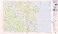
~ Tappahannock VA topo map, 1:100000 scale, 30 X 60 Minute, Historical, 1984, updated 1985
Tappahannock, Virginia, USGS topographic map dated 1984.
Includes geographic coordinates (latitude and longitude). This topographic map is suitable for hiking, camping, and exploring, or framing it as a wall map.
Printed on-demand using high resolution imagery, on heavy weight and acid free paper, or alternatively on a variety of synthetic materials.
Topos available on paper, Waterproof, Poly, or Tyvek. Usually shipping rolled, unless combined with other folded maps in one order.
- Product Number: USGS-5303692
- Free digital map download (high-resolution, GeoPDF): Tappahannock, Virginia (file size: 8 MB)
- Map Size: please refer to the dimensions of the GeoPDF map above
- Weight (paper map): ca. 55 grams
- Map Type: POD USGS Topographic Map
- Map Series: HTMC
- Map Verison: Historical
- Cell ID: 68439
- Scan ID: 188809
- Imprint Year: 1985
- Woodland Tint: Yes
- Aerial Photo Year: 1982
- Edit Year: 1984
- Datum: NAD27
- Map Projection: Universal Transverse Mercator
- Planimetric: Yes
- Map published by United States Geological Survey
- Map Language: English
- Scanner Resolution: 400 dpi
- Map Cell Name: Tappahannock
- Grid size: 30 X 60 Minute
- Date on map: 1984
- Map Scale: 1:100000
- Geographical region: Virginia, United States
Neighboring Maps:
All neighboring USGS topo maps are available for sale online at a variety of scales.
Spatial coverage:
Topo map Tappahannock, Virginia, covers the geographical area associated the following places:
- Dunton (historical) - Amburg - Callao - Crouch - Fairport - Merry Point - Wares Wharf - West Irvington - Nimcock (historical) - Haynesville - Iberis - Red Hill - Remo - Folly - Griffins Landing - Westland - Cove Colony - Island Farm - Farley Park Corner - Crabbe Mill - Irvington - Pierces Corner - Lodge - Lankford Corner - Powcan - Dragonville - Romancoke - Batt - Cobbs Creek - Urbanna - Totuskey - New Kent - Dahlgrens Corner - Grafton - Cumberland Landing - Bundick - Revis - Weems - Brookeshire - Downings Corner - Chesapeake Beach - Fairfield Landing - Brays Fork - Williams Corner - Matchot (historical) - Caret - Newtown - Velma - Brays - Pitmans Corner - Gillick Corner - Wilton - Smith Island - Lancaster - Christchurch - Morattico - Gwynn - Gonyon - Threeway - Jetts Store - Cobham Park - Hornets Nest - Samos - Nesting - Ethel - Deltaville - Ruark - Chestnut Grove - White Stone - Warsaw - Coldwater - Church View - Slabtown - Browns Corner - Ozeana - Stampers - Elsom - Rhodes Point - Oak Grove - Kennard - Oakley Landing - Jenkins Landing - Lanesville - Shacklefords - Free Shade Corner - Butylo - Walkers Corner - Cheaden (historical) - Longist Forks - Allen Shop Corner - Woodstock - Stormont - Locust Hill - Bridgetown (historical) - Moon Corner - Clancie - Hyacinth - Middletons Corner - Upright - Simons Corner
- Map Area ID: AREA3837.5-77-76
- Northwest corner Lat/Long code: USGSNW38-77
- Northeast corner Lat/Long code: USGSNE38-76
- Southwest corner Lat/Long code: USGSSW37.5-77
- Southeast corner Lat/Long code: USGSSE37.5-76
- Northern map edge Latitude: 38
- Southern map edge Latitude: 37.5
- Western map edge Longitude: -77
- Eastern map edge Longitude: -76


