
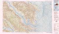
~ Tappahannock VA topo map, 1:100000 scale, 30 X 60 Minute, Historical, 1984
Tappahannock, Virginia, USGS topographic map dated 1984.
Includes geographic coordinates (latitude and longitude). This topographic map is suitable for hiking, camping, and exploring, or framing it as a wall map.
Printed on-demand using high resolution imagery, on heavy weight and acid free paper, or alternatively on a variety of synthetic materials.
Topos available on paper, Waterproof, Poly, or Tyvek. Usually shipping rolled, unless combined with other folded maps in one order.
- Product Number: USGS-5303690
- Free digital map download (high-resolution, GeoPDF): Tappahannock, Virginia (file size: 14 MB)
- Map Size: please refer to the dimensions of the GeoPDF map above
- Weight (paper map): ca. 55 grams
- Map Type: POD USGS Topographic Map
- Map Series: HTMC
- Map Verison: Historical
- Cell ID: 68439
- Scan ID: 188808
- Woodland Tint: Yes
- Visual Version Number: 2
- Aerial Photo Year: 1982
- Edit Year: 1984
- Datum: NAD27
- Map Projection: Universal Transverse Mercator
- Map published by United States Geological Survey
- Map Language: English
- Scanner Resolution: 400 dpi
- Map Cell Name: Tappahannock
- Grid size: 30 X 60 Minute
- Date on map: 1984
- Map Scale: 1:100000
- Geographical region: Virginia, United States
Neighboring Maps:
All neighboring USGS topo maps are available for sale online at a variety of scales.
Spatial coverage:
Topo map Tappahannock, Virginia, covers the geographical area associated the following places:
- Jamaica - Oakwood Mobile Home Park - Bestland - Lewisetta - Owl Trap - Coldwater - Chestnut Grove - Stingray Point - White Oak Landing - White Oak Landing - Harcum - Dunbrooke - Totuskey - Cooks Corner - Wildwood Beach - Coan - Lively - Island Farm - Reedville - Gordon Landing - Millers Tavern - Oakley Landing - Hardyville - Deltaville - Milestone - Lake - Cumnor - Rexburg - Mount Landing - Crouch - Pauls Crossroads - Christ Church - Hogans Hill - Cumnberland (historical) - Fairplay - Richmond Beach - Fairport - Ottoman - Ocran - Jacks Fork - Bruington - Lottsburg - Free Shade Corner - McNeals Corner - Hornets Nest - Gibeon - Crabbe Mill - Dodlyt - Harveys - Nimcock (historical) - Monaskon - Irvington - Village - Lowerys Point Landing - Lara - Folly - Boer - Middletons Corner - Shacklefords Fork - Hardins Corner - Hillsboro - Sandy Bottom (historical) - Carlton Corner - Burtons Corner - Fleeton - Taft - Mount Zion - Williams Corner - Cowart - Downings - Moon Corner - Regent - Church View - Nohead Bottom - Ditchley - Chesapeake Beach - White Stone - Remlik - Lowerys Landing - Cumberland Landing - Mulch - Oakley - Ethel - Grace Point - Christchurch - Walmsley - Log Landing - Freeport - Stevensville - Merry Point - Amburg - Blundon Corner - Lodge - Pigeon Hill - Gwynn - Pierces Corner - Center Cross - Lankford Corner - Bertrand - Cohoke
- Map Area ID: AREA3837.5-77-76
- Northwest corner Lat/Long code: USGSNW38-77
- Northeast corner Lat/Long code: USGSNE38-76
- Southwest corner Lat/Long code: USGSSW37.5-77
- Southeast corner Lat/Long code: USGSSE37.5-76
- Northern map edge Latitude: 38
- Southern map edge Latitude: 37.5
- Western map edge Longitude: -77
- Eastern map edge Longitude: -76


