
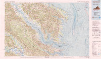
~ Tappahannock VA topo map, 1:100000 scale, 30 X 60 Minute, Historical, 1984, updated 1990
Tappahannock, Virginia, USGS topographic map dated 1984.
Includes geographic coordinates (latitude and longitude). This topographic map is suitable for hiking, camping, and exploring, or framing it as a wall map.
Printed on-demand using high resolution imagery, on heavy weight and acid free paper, or alternatively on a variety of synthetic materials.
Topos available on paper, Waterproof, Poly, or Tyvek. Usually shipping rolled, unless combined with other folded maps in one order.
- Product Number: USGS-5303688
- Free digital map download (high-resolution, GeoPDF): Tappahannock, Virginia (file size: 14 MB)
- Map Size: please refer to the dimensions of the GeoPDF map above
- Weight (paper map): ca. 55 grams
- Map Type: POD USGS Topographic Map
- Map Series: HTMC
- Map Verison: Historical
- Cell ID: 68439
- Scan ID: 188807
- Imprint Year: 1990
- Woodland Tint: Yes
- Visual Version Number: 1
- Aerial Photo Year: 1982
- Edit Year: 1984
- Datum: NAD27
- Map Projection: Universal Transverse Mercator
- Map published by United States Geological Survey
- Map Language: English
- Scanner Resolution: 400 dpi
- Map Cell Name: Tappahannock
- Grid size: 30 X 60 Minute
- Date on map: 1984
- Map Scale: 1:100000
- Geographical region: Virginia, United States
Neighboring Maps:
All neighboring USGS topo maps are available for sale online at a variety of scales.
Spatial coverage:
Topo map Tappahannock, Virginia, covers the geographical area associated the following places:
- Lilian - Center Cross - Sunnybank - Velma - Middletons Corner - Vir-Mar Beach - Simonson - Cologne - Ivondale - Gibeon - Irvington - Nesting - Henleys Fork - Beverlyville - Wares Wharf - Red Hill - Grinels - Jetts Store - Walmsley - Rickahock - Port Richmond - Good Luck - Bundick - Deltaville - Hornets Nest - Bridgetown (historical) - Johnson Landing - Hamlins Corner - Mollusk - Lowerys Landing - Cowart - Mascot - Farnham - Eubank - Dutton (historical) - Nuttsville - Lively - Locklies - Lewisetta - Fairplay - Callao - Caret - Milestone - Monaskon - Kilmarnock - Highland Landing - Indian Field - Pine Tree - Mattaponi - Revis - Boer - Cobbs Creek - Cumnor - West Irvington - Totuskey - Robley - Laneview - Westland - Ethel - Harmony Village - Hardyville - Ocran - Village - Brook Vale - Richmond Beach - Bushy - Regent - Pigeon Hill - Powcan - Hillsboro - Stormont - Cohoke - Hartfield - Brays - Williams Corner - White Oak Landing - Lodge - Rich Neck - Millers Tavern - Gillick Corner - Lee Dale Shores - Tylerton - Waddeys - Hardins Corner - Somers - Foxwells - Burgess - Downings Corner - Fairport - Little Plymouth - Tibitha - Howertons - Clancie - Butylo - Healys - Ophelia - Harcum - Hyacinth - Mount Olive - Lyells
- Map Area ID: AREA3837.5-77-76
- Northwest corner Lat/Long code: USGSNW38-77
- Northeast corner Lat/Long code: USGSNE38-76
- Southwest corner Lat/Long code: USGSSW37.5-77
- Southeast corner Lat/Long code: USGSSE37.5-76
- Northern map edge Latitude: 38
- Southern map edge Latitude: 37.5
- Western map edge Longitude: -77
- Eastern map edge Longitude: -76


