
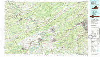
~ Radford VA topo map, 1:100000 scale, 30 X 60 Minute, Historical, 1982, updated 1983
Radford, Virginia, USGS topographic map dated 1982.
Includes geographic coordinates (latitude and longitude). This topographic map is suitable for hiking, camping, and exploring, or framing it as a wall map.
Printed on-demand using high resolution imagery, on heavy weight and acid free paper, or alternatively on a variety of synthetic materials.
Topos available on paper, Waterproof, Poly, or Tyvek. Usually shipping rolled, unless combined with other folded maps in one order.
- Product Number: USGS-5303670
- Free digital map download (high-resolution, GeoPDF): Radford, Virginia (file size: 26 MB)
- Map Size: please refer to the dimensions of the GeoPDF map above
- Weight (paper map): ca. 55 grams
- Map Type: POD USGS Topographic Map
- Map Series: HTMC
- Map Verison: Historical
- Cell ID: 68208
- Scan ID: 188797
- Imprint Year: 1983
- Woodland Tint: Yes
- Visual Version Number: 2
- Aerial Photo Year: 1977
- Edit Year: 1982
- Datum: NAD27
- Map Projection: Universal Transverse Mercator
- Map published by United States Geological Survey
- Map Language: English
- Scanner Resolution: 600 dpi
- Map Cell Name: Radford
- Grid size: 30 X 60 Minute
- Date on map: 1982
- Map Scale: 1:100000
- Geographical region: Virginia, United States
Neighboring Maps:
All neighboring USGS topo maps are available for sale online at a variety of scales.
Spatial coverage:
Topo map Radford, Virginia, covers the geographical area associated the following places:
- Vermont Heights - Rolling Hills - Lynn Dell Estates - Elliston - Shelor Acres - Altoona Mines (historical) - University Terrace - Lake View - Haven Heights - Catawba - Rogers - Woodlawn - Fairlawn - Dunton Addition - Victory Heights - Snidow Heights - Bluff City - Carlton Park - Goodwins Ferry (historical) - Algoma - Ponderosa Park - Piedmont - Monticello Estates - Dublin - Blake Forest - Old Farm Village - Poplar Hill - Plainview - West Club Forest - Moomaw Heights - Morwanda Park - Fairview - Woodbine - Locust Grove Park - Lindside - Kerner - Meadow Wood Estates - Poages Mill - Karen Hills - Cashmere - Mount Tabor Village - Wynmere - Willowton - Adam Acres - Mitchell - Alta View - Kire - Waiteville - Beverly Heights North - Chestnut Knob - Boxwood Hills - Prospectdale - Brooklyn - Churchwood (historical) - Staffordsville - Laurel Hills - Edgewood - Huddleston Court - Lynwood Terrace - Foxwood - Wedgewood Forest - Blackwood - Radford Village - French - Vista Via - Berwick Heights - Orchard View - Southside Hills - Willow Woods - Wabash (historical) - Kimball Acres - Bonvue Heights - Mercers Saltworks (historical) - Palmer - Orchard Heights - Fort Lewis Terrace - Lovern - Webbs Mill - Kenwick Place - Hunters Ridge - Norwood - Grandview Gardens - Mount Tabor - Whitethorne - Silver Lake Heights - Green Hill Terrace - Crestwood Gardens - Airview Court - Hethwood - Holly Ridge - Southgate - Abbott - Dickerson - Blacksburg - Vicker Heights - Spring Garden - Lerona - Belle Meade - The Pines - Pearisburg
- Map Area ID: AREA37.537-81-80
- Northwest corner Lat/Long code: USGSNW37.5-81
- Northeast corner Lat/Long code: USGSNE37.5-80
- Southwest corner Lat/Long code: USGSSW37-81
- Southeast corner Lat/Long code: USGSSE37-80
- Northern map edge Latitude: 37.5
- Southern map edge Latitude: 37
- Western map edge Longitude: -81
- Eastern map edge Longitude: -80


