
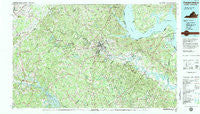
~ Fredericksburg VA topo map, 1:100000 scale, 30 X 60 Minute, Historical, 1983, updated 1984
Fredericksburg, Virginia, USGS topographic map dated 1983.
Includes geographic coordinates (latitude and longitude). This topographic map is suitable for hiking, camping, and exploring, or framing it as a wall map.
Printed on-demand using high resolution imagery, on heavy weight and acid free paper, or alternatively on a variety of synthetic materials.
Topos available on paper, Waterproof, Poly, or Tyvek. Usually shipping rolled, unless combined with other folded maps in one order.
- Product Number: USGS-5303644
- Free digital map download (high-resolution, GeoPDF): Fredericksburg, Virginia (file size: 27 MB)
- Map Size: please refer to the dimensions of the GeoPDF map above
- Weight (paper map): ca. 55 grams
- Map Type: POD USGS Topographic Map
- Map Series: HTMC
- Map Verison: Historical
- Cell ID: 67547
- Scan ID: 188784
- Imprint Year: 1984
- Woodland Tint: Yes
- Visual Version Number: 1
- Aerial Photo Year: 1977
- Edit Year: 1983
- Datum: NAD27
- Map Projection: Universal Transverse Mercator
- Map published by United States Geological Survey
- Map Language: English
- Scanner Resolution: 600 dpi
- Map Cell Name: Fredericksburg
- Grid size: 30 X 60 Minute
- Date on map: 1983
- Map Scale: 1:100000
- Geographical region: Virginia, United States
Neighboring Maps:
All neighboring USGS topo maps are available for sale online at a variety of scales.
Spatial coverage:
Topo map Fredericksburg, Virginia, covers the geographical area associated the following places:
- Young Corner - Barrett Heights - Gauntlet Estates - Monroe Estates - Penny Corner - Stevensburg - Ashburn Hills - Woodlanding Village - Collins Crossing - Taylors - Glendie - Colbert Walker Estates - Dahlgren Junction (historical) - Richardsville South - Decatur (historical) - Fairview and Oakland - Old Banks - Barrett Knolls - Samuels Corner - Rose Hill Farms - Austin Ridge - Heflin - Green Manor Estates - Range Corner - Country Ridge - Whitson Run - Everona - Liberty - Windsor Forest - Grafton Village - North Potomac - Grays Steven Tract - Cannon Ridge - Sky Terrace - Chapalita - High School Heights - Coal Landing - Sealston - Shady Grove Corner - Claiborne - Hicks Mill - Heritage Oaks - Marye - Summerwood - Marlboro - Glenora - Winfrey - Holly Acres - Vista Woods - Cresent Pointe - Ambar - Thornhill - Dartmoor - Eubank Corner - Woodford - Somerset Beach - Indian Town - Thorny Point Farm - Lahore - Hooes - Mount Pleasant - Marshope - Porters - Little Falls Village - Hartwood Meadows - Rivendell - Daltons - Storck Run - Olney Corner - Stanards Mill - Silver Hill - Harris - Joseph Sullivan Estates - Sheltons Run - Berea Plantation - Holly Corner Estates - Welchs - Chapel View - Foxberry - King George - Mount Holly - Stefaniga Road - Massaponax - Locks Corner - Keatwood - Stones Corner - Devon Green - Goldmans Corner - Briarwood Estates - Kings Grant - Woodland - Sunnyside Division - Ferry Road - Belvedere - Sutton Acres - New Post - Barrington Woods - Arcadia - Cranes Corner - Park
- Map Area ID: AREA38.538-78-77
- Northwest corner Lat/Long code: USGSNW38.5-78
- Northeast corner Lat/Long code: USGSNE38.5-77
- Southwest corner Lat/Long code: USGSSW38-78
- Southeast corner Lat/Long code: USGSSE38-77
- Northern map edge Latitude: 38.5
- Southern map edge Latitude: 38
- Western map edge Longitude: -78
- Eastern map edge Longitude: -77


