
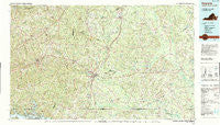
~ Emporia VA topo map, 1:100000 scale, 30 X 60 Minute, Historical, 1990, updated 1990
Emporia, Virginia, USGS topographic map dated 1990.
Includes geographic coordinates (latitude and longitude). This topographic map is suitable for hiking, camping, and exploring, or framing it as a wall map.
Printed on-demand using high resolution imagery, on heavy weight and acid free paper, or alternatively on a variety of synthetic materials.
Topos available on paper, Waterproof, Poly, or Tyvek. Usually shipping rolled, unless combined with other folded maps in one order.
- Product Number: USGS-5303642
- Free digital map download (high-resolution, GeoPDF): Emporia, Virginia (file size: 26 MB)
- Map Size: please refer to the dimensions of the GeoPDF map above
- Weight (paper map): ca. 55 grams
- Map Type: POD USGS Topographic Map
- Map Series: HTMC
- Map Verison: Historical
- Cell ID: 67478
- Scan ID: 188783
- Imprint Year: 1990
- Woodland Tint: Yes
- Aerial Photo Year: 1987
- Edit Year: 1990
- Datum: NAD27
- Map Projection: Universal Transverse Mercator
- Map published by United States Geological Survey
- Map Language: English
- Scanner Resolution: 600 dpi
- Map Cell Name: Emporia
- Grid size: 30 X 60 Minute
- Date on map: 1990
- Map Scale: 1:100000
- Geographical region: Virginia, United States
Neighboring Maps:
All neighboring USGS topo maps are available for sale online at a variety of scales.
Spatial coverage:
Topo map Emporia, Virginia, covers the geographical area associated the following places:
- Barley - Lawrenceville Hills - Dahlia - Danieltown - Harris Crossroads - Magnums Mobile Home Park - Cross Keys - Dory - Walnut Heights - Rivers Edge - Lambs - Pleasant Hill - Bowers Corner - Gaskins (historical) - Owens - Turners Crossroads - Baskerville Mill - Pine View Mobile Home Park - Jarratt - West Hope - Lawrenceville - Warfield - Kingsberry - Callaville - Vicksville - Tobacco - North Emporia - Bufford Crossroads - Drewryville - Como - Champ - Paris Store - Gum - Lakeside Village Mobile Home Park - Statesville - Winfields Mill - Webbs Mill - Bryants Corner - Alberta - Octagon - Hugo - Courtland - Otterdam Mobile Home Park - Cashs Corner - Drakes Corner - Ante - Vineland (historical) - Durand - Truit - Concord - Bennets Crossroads - Newsoms - Hicks Mill - Handsom - Homeville - Cowie Corner - Brewers Crossroads - Vincent Grove - Meredithville - Margarettsville - Old Fitzhugh - Bowens Corner - Jonesboro (historical) - Barrows Store - Ankum - Stony Creek - Sebrell - Chub (historical) - Stancell - Southside Shores - Beales - Westover Hills - Gray - Grizzard - Little Texas - Severn - Kennons (historical) - Emporia - Fort Christanna - Delbridge Estates - Fields Crossroads - Edmunds Store - Totaro - Ordsburg - Pea Hill Estates - Ezell - Drumgoole (historical) - Booker - Cochran - Brink - Pea Hill Shores - Edgerton - Elams - Dolphin - Sturgeonville - Mitchells Mill - Henrico - Angelico - Barrett Corner - Delaware Park
- Map Area ID: AREA3736.5-78-77
- Northwest corner Lat/Long code: USGSNW37-78
- Northeast corner Lat/Long code: USGSNE37-77
- Southwest corner Lat/Long code: USGSSW36.5-78
- Southeast corner Lat/Long code: USGSSE36.5-77
- Northern map edge Latitude: 37
- Southern map edge Latitude: 36.5
- Western map edge Longitude: -78
- Eastern map edge Longitude: -77


